• Skip to content
  • Skip to navigation
Print header
X

  • (07) 4970 0700
  • Online Services

«Back to
Gladstone Regional Council

Version 2 - Current Planning Scheme

  • Citation and commencement
  • Part 1 About the planning scheme
      BackPart 1 About the planning scheme
    • 1.1 Introduction
    • 1.2 Planning scheme components
    • 1.3 Interpretation
    • 1.4 Categories of development
    • 1.5 Hierarchy of assessment benchmarks
    • 1.6 Building work regulated under the planning scheme
    • 1.7 Local government administrative matters
  • Part 2 State planning provisions
      BackPart 2 State planning provisions
    • 2.1 State planning policy
    • 2.2 Regional plan
    • 2.3 Referral agency delegations
    • 2.4 Regulated requirements
  • Part 3 Strategic framework
      BackPart 3 Strategic framework
    • 3.1 Preliminary
    • 3.2 Strategic intent
        Back3.2 Strategic intent
      • The Gladstone Region Places Model
    • 3.3 Gateway to the world
    • 3.4 Community living
    • 3.5 Connecting our places
    • 3.6 Building it better: our urban areas
    • 3.7 Our environment and heritage
    • 3.8 Our rural and coastal townships and places
  • Part 4 Local Government Infrastructure Plan (LGIP)
      BackPart 4 Local Government Infrastructure Plan (LGIP)
    • 4.1 Preliminary
    • ​4.2 Planning assumptions Open
        Back​4.2 Planning assumptions
      • 4.2.1 Purpose
      • ​​4.2.2 Population and employment growth
      • ​4.2.3 Priority infrastructure area
      • ​​4.2.4 Desired standards of service
      • 4.2.5 Plans for trunk infrastructure
      • 4.2.7 Schedules of works
      • 4.2.8 Extrinsic material
  • Part 5 Tables of assessment
      BackPart 5 Tables of assessment
    • 5.1 Preliminary
    • 5.2 Reading the tables
    • 5.3 Categories of development and assessment
    • 5.4 Regulated categories of development and categories of assessment prescribed by the Regulation
    • 5.5 Categories of development and assessment—Material change of use Open
        Back5.5 Categories of development and assessment—Material change of use
      • 5.5.1 Low density residential zone
      • 5.5.2 Low-medium density residential zone
      • 5.5.3 Medium density residential zone
      • 5.5.4 Character residential zone
      • 5.5.5 Emerging community zone
      • 5.5.6 Mixed use zone
      • 5.5.7 Centre zone
      • 5.5.8 Principal centre zone
      • 5.5.9 Neighbourhood centre zone
      • 5.5.10 Specialised centre zone
      • 5.5.11 Low impact industry zone
      • 5.5.12 Medium impact industry zone
      • 5.5.13 Special industry zone
      • 5.5.14 Industry investigation zone
      • 5.5.15 Special purpose zone
      • 5.5.16 Rural zone
      • 5.5.17 Rural residential zone
      • 5.5.18 Township zone
      • 5.5.19 Major tourism zone
      • 5.5.20 Minor tourism zone
      • 5.5.21 Community facilities zone
      • 5.5.22 Sport and recreation zone
      • 5.5.23 Open space zone
      • 5.5.24 Environmental management zone
      • 5.5.25 Conservation zone
      • 5.5.26 Limited development zone (constrained land)
    • 5.6 Categories of development and assessment: Reconfiguring a lot
    • 5.7 Categories of development and assessment: Building work
    • 5.8 Categories of development and assessment: Operational work
    • 5.9 Categories of development and assessment: Local plans
    • 5.10 Categories of development and assessment: Overlays
  • Part 6 Zones
      BackPart 6 Zones
    • 6.2 Zone codes Open
        Back6.2 Zone codes
      • 6.2.1 Low density residential
      • 6.2.2 Low–medium density residential
      • 6.2.3 Medium density residential
      • 6.2.4 Character residential
      • 6.2.5 Centre
      • 6.2.6 Principal centre
      • 6.2.7 Neighbourhood centre
      • 6.2.8 Sport and recreation
      • 6.2.9 Open space
      • 6.2.10 Environmental management
      • 6.2.11 Conservation
      • 6.2.12 Low impact industry
      • 6.2.13 Medium impact industry
      • 6.2.14 Special industry
      • 6.2.15 Industry investigation
      • 6.2.16 Major tourism
      • 6.2.17 Minor tourism
      • 6.2.18 Community facilities
      • 6.2.19 Emerging community
      • 6.2.20 Limited development
      • 6.2.21 Mixed use
      • 6.2.22 Rural
      • 6.2.23 Rural residential
      • 6.2.24 Special purpose
      • 6.2.25 Specialised centre
      • 6.2.26 Township
  • Part 7 Local plans
  • Part 8 Overlays
      BackPart 8 Overlays
    • 8.2 Overlay codes Open
        Back8.2 Overlay codes
      • 8.2.1 Acid sulfate soils
      • 8.2.2 Airport environs
      • 8.2.3 Biodiversity
      • 8.2.4 Bushfire hazard
      • 8.2.5 Coastal hazard
      • 8.2.6 Extractive resources and minerals
      • 8.2.7 Flood hazard
      • 8.2.8 Hazardous activities
      • 8.2.9 Heritage
      • 8.2.10 Regional infrastructure
      • 8.2.11 Scenic amenity
      • 8.2.12 Steep land
      • 8.2.13 Water resource catchment
  • Part 9 Development codes
      BackPart 9 Development codes
    • 9.2 Development that cannot be made assessable in accordance with Schedule 6 of the Planning Regulation 2017
    • 9.3 Use codes Open
        Back9.3 Use codes
      • 9.3.1 Advertising devices
      • 9.3.2 Development design
      • 9.3.3 Extractive industry
      • 9.3.4 Home based business
      • 9.3.5 Landscaping
      • 9.3.6 Operational works
      • 9.3.7 Reconfiguring a lot
      • 9.3.8 Telecommunications facility use
  • Part 10 Other plans
  • Schedule 1 Definitions
      BackSchedule 1 Definitions
    • SC1.1 Use definitions Open
        BackSC1.1 Use definitions
      • SC1.1.1 Defined activity groups
      • SC1.1.2 Industry thresholds
      • Table Sc1.1.1—Index of use definitions
    • SC1.2 Administrative definitions
  • Schedule 2 Mapping
  • Schedule 3 Local Government Infrastructure Plan (LGIP) mapping and tables
      BackSchedule 3 Local Government Infrastructure Plan (LGIP) mapping and tables
    • SC3.1 Planning assumptions tables
    • SC3.2 Schedules of works
    • SC3.3 Local government infrastructure plan maps​
    • SC3.4 Glossary and abbreviations
  • Schedule 4 Notations required under the Planning Act 2016
  • Schedule 5 Land designated for community infrastructure
  • Schedule 6 Planning scheme policies
      BackSchedule 6 Planning scheme policies
    • SC6.1 Planning scheme policy index
    • SC6.2 Engineering design
    • SC6.3 Plans of development
    • SC6.4​ Community and economic needs assessment
    • SC6.5​ CBD redevelopment
    • SC6.6​ Beecher/Burua constant flow precinct
    • SC6.7 Flood hazard
    • SC6.8 Heritage
    • SC6.9 Non–resident workers accommodation
    • SC6.10 Vehicle parking rates
    • SC6.11 Waste management
  • Appendices
Version 2 - Current Planning Scheme
  1. Home
  2. Version 2 - Current Planning Scheme
  3. Part 3 Strategic framework
  4. 3.2 Strategic intent
Back
Online Mapping

3.2 Strategic intent

The Gladstone region story: from now to its preferred future

Gladstone is a region of contrasts. It is made up of places that exhibit different qualities and experiences, different types of growth and planning related challenges. It has long been a major industrial powerhouse of the Queensland economy.  The city and its surrounding urban areas have experienced almost 50 years of major industry, port and economic development investment and is a focal point of the Queensland economy. This has led to the rapid growth of a number of urban areas including the city itself, Boyne Island, Tannum Sands and Calliope. The region also includes a large and diverse hinterland with numerous villages and towns in coastal and rural settings.

This growth is built on the area's natural and man–made assets such as the safe deep water harbour, abundant water storage, land, power and limestone, sand and hard rock resources – which underpin the region's emerging role as a global energy hub, exporting coal, gas and shale oil. This in turn has positioned the region as a logical location for value adding industry, plus transport and logistics opportunities to support these roles.

The region has experienced a series of 'booms' associated with major new industry and port development. These booms have seen unprecedented levels of major economic activity related to mining and gas, port operations, and major industry, ranging from the LNG plants on Curtis Island, major port expansion at Wiggins Island, and the development of the Gladstone State Development Area (GSDA).

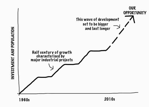
These booms create tremendous economic development opportunities and also major pressures where this growth is taking place, with less investment occurring outside of these areas. The growth is not plain sailing – it creates significant pressures on other sectors of its economy, urban development, infrastructure, community, services, and the region's environment. The latest boom represents a significant opportunity in Gladstone's history to make the most of this situation for the long term benefit of people living and working in the region, as indicatively captured in the graph below:

3.2 Graph 

Like the urban growth areas of Gladstone, Boyne Island, Tannum Sands and Calliope, the coastal and rural towns and areas are important components of the Gladstone region. Although many of these places are some distance from the high growth areas, it is desirable that the benefits of major resource and industrial related development be shared by the whole region. It is also desirable these places retain their character and lifestyle attributes.

So our overall intent for the Gladstone region is:

Getting the balance right: local benefits from global growth

This strategic intent has two primary aims:

  1. To recognise that some parts of the region shoulder a major economic load, because of their role in the global economy as a focus for major industrial development, major port facilities, and other related investment which is fundamental to the continued economic prosperity of the State and nation. The community wants to ensure that this global role benefits the Gladstone region as well as the State and nation.
  2. For the region to be nationally recognised as achieving the best possible balance of large industry, sustainability, community wellbeing and environmental protection. This will be attained through a preferred settlement pattern and infrastructure strategy capable of responding to the needs of major industrial growth surges, and the setting of a development framework that will create a region of vibrant, sustainable and affordable neighbourhoods where residents feel supported and engaged.

This strategic framework is about a 'rebalancing' process, through the planning scheme (and other initiatives of the Council) to achieve great outcomes for the people living and working in the Gladstone region as well as for Queensland.

Conceptually, it is about moving from this…

3 2 Balance 

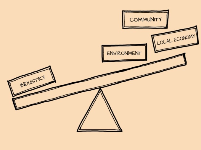
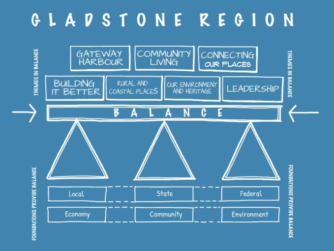
… to the region's preferred future:

3.2 Balance future 

It is in everyone's interest to balance these major economic opportunities with community and environmental aspects, to create a mature region of complete communities which provide genuine choice and support for all its residents, workers and visitors.

This will benefit:

  • major industries investing in the region, because it ensures that those who work and live in the area have access to the housing and services they need, and choice of lifestyles which keep them connected to, and happy in, the Gladstone region
  • the regional community, because its people have access to lifestyle choices, appropriate housing and essential services
  • the regional environment, including those areas of national and state environmental significance, which is protected and can sustain the industry and urban components of the region, and
  • Queensland, as it underpins the sustainable economic development of Gladstone as Queensland's premier industrial capital and gateway harbour to the world, thereby providing great economic outcomes for the State in the global economy.

The foundations for these balanced outcomes are:

  • the economic, community and environmental components which support the balanced outcome, and
  • the efforts of governments at all three levels, (the regional Council, the State and Federal governments) to achieve those balanced outcomes.

This balance is also about providing choice (of lifestyle, employment, housing, etc), integration (between the area's economic activities, community life and environmental values), and sustainability (through the planning scheme guiding the development of the region to outcomes consistent with this overall vision).

Online Mapping

Version 2 - Current Planning Scheme

SELECT
  • Citation and commencement
  • Part 1 About the planning scheme
      BackPart 1 About the planning scheme
    • 1.1 Introduction
    • 1.2 Planning scheme components
    • 1.3 Interpretation
    • 1.4 Categories of development
    • 1.5 Hierarchy of assessment benchmarks
    • 1.6 Building work regulated under the planning scheme
    • 1.7 Local government administrative matters
  • Part 2 State planning provisions
      BackPart 2 State planning provisions
    • 2.1 State planning policy
    • 2.2 Regional plan
    • 2.3 Referral agency delegations
    • 2.4 Regulated requirements
  • Part 3 Strategic framework
      BackPart 3 Strategic framework
    • 3.1 Preliminary
    • 3.2 Strategic intent
        Back3.2 Strategic intent
      • The Gladstone Region Places Model
    • 3.3 Gateway to the world
    • 3.4 Community living
    • 3.5 Connecting our places
    • 3.6 Building it better: our urban areas
    • 3.7 Our environment and heritage
    • 3.8 Our rural and coastal townships and places
  • Part 4 Local Government Infrastructure Plan (LGIP)
      BackPart 4 Local Government Infrastructure Plan (LGIP)
    • 4.1 Preliminary
    • ​4.2 Planning assumptions Open
        Back​4.2 Planning assumptions
      • 4.2.1 Purpose
      • ​​4.2.2 Population and employment growth
      • ​4.2.3 Priority infrastructure area
      • ​​4.2.4 Desired standards of service
      • 4.2.5 Plans for trunk infrastructure
      • 4.2.7 Schedules of works
      • 4.2.8 Extrinsic material
  • Part 5 Tables of assessment
      BackPart 5 Tables of assessment
    • 5.1 Preliminary
    • 5.2 Reading the tables
    • 5.3 Categories of development and assessment
    • 5.4 Regulated categories of development and categories of assessment prescribed by the Regulation
    • 5.5 Categories of development and assessment—Material change of use Open
        Back5.5 Categories of development and assessment—Material change of use
      • 5.5.1 Low density residential zone
      • 5.5.2 Low-medium density residential zone
      • 5.5.3 Medium density residential zone
      • 5.5.4 Character residential zone
      • 5.5.5 Emerging community zone
      • 5.5.6 Mixed use zone
      • 5.5.7 Centre zone
      • 5.5.8 Principal centre zone
      • 5.5.9 Neighbourhood centre zone
      • 5.5.10 Specialised centre zone
      • 5.5.11 Low impact industry zone
      • 5.5.12 Medium impact industry zone
      • 5.5.13 Special industry zone
      • 5.5.14 Industry investigation zone
      • 5.5.15 Special purpose zone
      • 5.5.16 Rural zone
      • 5.5.17 Rural residential zone
      • 5.5.18 Township zone
      • 5.5.19 Major tourism zone
      • 5.5.20 Minor tourism zone
      • 5.5.21 Community facilities zone
      • 5.5.22 Sport and recreation zone
      • 5.5.23 Open space zone
      • 5.5.24 Environmental management zone
      • 5.5.25 Conservation zone
      • 5.5.26 Limited development zone (constrained land)
    • 5.6 Categories of development and assessment: Reconfiguring a lot
    • 5.7 Categories of development and assessment: Building work
    • 5.8 Categories of development and assessment: Operational work
    • 5.9 Categories of development and assessment: Local plans
    • 5.10 Categories of development and assessment: Overlays
  • Part 6 Zones
      BackPart 6 Zones
    • 6.2 Zone codes Open
        Back6.2 Zone codes
      • 6.2.1 Low density residential
      • 6.2.2 Low–medium density residential
      • 6.2.3 Medium density residential
      • 6.2.4 Character residential
      • 6.2.5 Centre
      • 6.2.6 Principal centre
      • 6.2.7 Neighbourhood centre
      • 6.2.8 Sport and recreation
      • 6.2.9 Open space
      • 6.2.10 Environmental management
      • 6.2.11 Conservation
      • 6.2.12 Low impact industry
      • 6.2.13 Medium impact industry
      • 6.2.14 Special industry
      • 6.2.15 Industry investigation
      • 6.2.16 Major tourism
      • 6.2.17 Minor tourism
      • 6.2.18 Community facilities
      • 6.2.19 Emerging community
      • 6.2.20 Limited development
      • 6.2.21 Mixed use
      • 6.2.22 Rural
      • 6.2.23 Rural residential
      • 6.2.24 Special purpose
      • 6.2.25 Specialised centre
      • 6.2.26 Township
  • Part 7 Local plans
  • Part 8 Overlays
      BackPart 8 Overlays
    • 8.2 Overlay codes Open
        Back8.2 Overlay codes
      • 8.2.1 Acid sulfate soils
      • 8.2.2 Airport environs
      • 8.2.3 Biodiversity
      • 8.2.4 Bushfire hazard
      • 8.2.5 Coastal hazard
      • 8.2.6 Extractive resources and minerals
      • 8.2.7 Flood hazard
      • 8.2.8 Hazardous activities
      • 8.2.9 Heritage
      • 8.2.10 Regional infrastructure
      • 8.2.11 Scenic amenity
      • 8.2.12 Steep land
      • 8.2.13 Water resource catchment
  • Part 9 Development codes
      BackPart 9 Development codes
    • 9.2 Development that cannot be made assessable in accordance with Schedule 6 of the Planning Regulation 2017
    • 9.3 Use codes Open
        Back9.3 Use codes
      • 9.3.1 Advertising devices
      • 9.3.2 Development design
      • 9.3.3 Extractive industry
      • 9.3.4 Home based business
      • 9.3.5 Landscaping
      • 9.3.6 Operational works
      • 9.3.7 Reconfiguring a lot
      • 9.3.8 Telecommunications facility use
  • Part 10 Other plans
  • Schedule 1 Definitions
      BackSchedule 1 Definitions
    • SC1.1 Use definitions Open
        BackSC1.1 Use definitions
      • SC1.1.1 Defined activity groups
      • SC1.1.2 Industry thresholds
      • Table Sc1.1.1—Index of use definitions
    • SC1.2 Administrative definitions
  • Schedule 2 Mapping
  • Schedule 3 Local Government Infrastructure Plan (LGIP) mapping and tables
      BackSchedule 3 Local Government Infrastructure Plan (LGIP) mapping and tables
    • SC3.1 Planning assumptions tables
    • SC3.2 Schedules of works
    • SC3.3 Local government infrastructure plan maps​
    • SC3.4 Glossary and abbreviations
  • Schedule 4 Notations required under the Planning Act 2016
  • Schedule 5 Land designated for community infrastructure
  • Schedule 6 Planning scheme policies
      BackSchedule 6 Planning scheme policies
    • SC6.1 Planning scheme policy index
    • SC6.2 Engineering design
    • SC6.3 Plans of development
    • SC6.4​ Community and economic needs assessment
    • SC6.5​ CBD redevelopment
    • SC6.6​ Beecher/Burua constant flow precinct
    • SC6.7 Flood hazard
    • SC6.8 Heritage
    • SC6.9 Non–resident workers accommodation
    • SC6.10 Vehicle parking rates
    • SC6.11 Waste management
  • Appendices

Gladstone Regional Council

Connect. Innovate. Diversify.

Return to top

Get in Touch

Phone

(07) 4970 0700

Opening Hours

8.30am - 5pm Monday to Friday

Social media

Contact Us  Email Us

Postal Address

PO Box 29, Gladstone Qld 4680

Council Offices

101 Goondoon Street, Gladstone Qld 4680
3 Don Cameron Drive, Calliope Qld 4680
41 Blomfield Street, Miriam Vale Qld 4677
Cnr Wyndham & Hayes Avenues, Boyne Island Qld 4680

Rural Transaction Centres

71 Springs Road, Agnes Water Qld 4677
47 Raglan Street, Mount Larcom Qld 4695

Footer Image Links

Gladstone Regional Council Logor Gladstone Entertainment Convention Centre Logo Gladstone Regional Art Gallery and Museum Logo Gladstone Regional Libraries Logo Gladstone Tondoon Botanic Gardens Logo Philip Street Communities and Families Precinct

Footer Acknowledgement

Gladstone Regional Council would like to acknowledge the Bailai, the Gurang, the Gooreng Gooreng and the Taribelang Bunda people who are the traditional custodians of this land. Gladstone Regional Council would also like to pay respect to Elders both past, present and emerging, and extend that respect to other Aboriginal and Torres Strait Islander people. Learn more about Council's Reconciliation Action Plan (RAP).

Chat Popup

Launch Chat

© 2025 Gladstone Regional Council

All content © Gladstone Regional Council Planning Scheme. All Rights Reserved.

Powered by Jadu Central.

  • Privacy
  • Right to Information
  • Login
Back to the top
Print footer