
Version 2 - Current Planning Scheme
- Citation and commencement
- Part 1 About the planning scheme
- Part 2 State planning provisions
- Part 3 Strategic framework
- Part 4 Local Government Infrastructure Plan (LGIP)
- Part 5 Tables of assessment
- Part 6 Zones
- Part 7 Local plans
- Part 8 Overlays
- Part 9 Development codes
- Part 10 Other plans
- Schedule 1 Definitions
- Schedule 2 Mapping
- Schedule 3 Local Government Infrastructure Plan (LGIP) mapping and tables
- Schedule 4 Notations required under the Planning Act 2016
- Schedule 5 Land designated for community infrastructure
- Schedule 6 Planning scheme policies
- Appendices
6.2.21 Mixed use
6.2.21.1 Application
This code applies to development where the code is identified as applicable in a table of assessment. When using this code, reference should be made to section 5.3.2 and where applicable, section 5.3.3 located in Part 5.
6.2.21.2 Purpose
Note—Primary frontages are identified on the Building height and frontages overlay map.
- The purpose of the mixed use zone code is to:
- Provide for a mixture of development that may include business, retail, residential, tourist accommodation, community, service industry, entertainment and associated services.
- Establish urban revitalisation areas in parts of the Valley, Toolooa Street west and the CBD fringe as high quality mixed use centres where people can live, work and play in Gladstone's inner city areas.
- Create an urban form characterised by high quality building design and streetscape outcomes.
- Ensure a level of amenity commensurate with an urbanised mixed use area.
- Provide opportunities for development which meets the short term accommodation needs of the resources and tourism sectors.
- The purpose of the zone will be achieved through the following overall outcomes:
Note—Primary frontages are identified on the Building height and frontages overlay map.
- A mix of uses and activities including small scale retail, commercial, tourism, service industry and residential uses are provided without detracting from the viability of the region's centres.
- A range of after-hours activities, particularly on primary frontages are promoted to support activation of the Valley where consistent with surrounding activity.
- The scale, character and built form of development contributes to a high standard of amenity.
- Development encourages and facilitates urban consolidation and the efficient use of physical and social infrastructure.
- Buildings are of a scale, height and size that complement the mixed use character for the area through design elements that reduce building bulk and create an attractive streetscape.
- Development creates pleasant living environments that ensure privacy, access to sunlight, open space, ventilation and natural climate control.
- Development is designed to incorporate sustainable practices including maximising energy efficiency, water conservation and public/active transport use.
- Development is supported by transport infrastructure that is designed to provide and promote safe and efficient public transport use, walking and cycling.
- Development is facilitated where uses provide a compact urban form.
- Development activates streets on primary frontages, promotes a mix of employment opportunities and enhances walking, cycling and public transport use.
- New development promotes and enhances Tank and Goondoon Streets as 'main streets' through high quality built form and streetscape treatments.
- Development responds to land constraints, including but not limited to bushfire, flooding and minimising changes to natural topography.
- Development mitigates any adverse impacts on adjoining areas of environmental significance, including creeks, gullies, waterways, wetlands, coastal areas, habitats, vegetation and bushland through location, design, operation and management requirements.
- Residential development is protected from the impacts of any nearby industrial activities, transport corridors, infrastructure, installations and major facilities.
- Development has access to development infrastructure and essential services.
- The purpose of the zone will also be achieved through the following additional overall outcomes for particular precincts.
- Jeffery Court precinct:
- Development supports coastal based tourism opportunities with a focus on Short term accommodation and small scale Food and drink outlets, Bars, retail and community uses. Other forms of Business and Centre activities are not supported.
- Development with frontage to the foreshore must provide continuous public access to Main Beach that includes connections with Tom Jeffery Memorial Park and more broadly with linkages along the foreshore between the Surf Club to the north and the Headland to the south.
- Development supports a mix of coastal tourism related uses and is of a height and scale that does not adversely impact on the coastal and visual character of the precinct or locality.
- Jeffery Court precinct:
6.2.21.3 Assessment benchmarks
Table 6.2.21.3.1—Accepted development subject to requirements and assessable development
| Performance outcomes | Acceptable outcomes |
|---|---|
Use – Caretaker's accommodation |
|
|
PO1 Development for caretaker's accommodation:
|
AO1.1 No more than 1 caretaker's accommodation unit is established on the site. |
|
AO1.2 Caretaker's accommodation is a maximum of 100m2 GFA. |
|
|
AO1.3 Caretaker's accommodation where on a primary frontage is located above the ground floor level, or to the rear of ground level business activities. Note—Primary frontages are identified on the Building height and frontages overlay map. |
|
|
AO1.4 Caretaker's accommodation is provided with a private open space area which:
|
|
| Use – Dwelling unit | |
|
PO2 Development does not compromise ground level business activities being established. |
AO2 Dwelling units are located either above the ground floor level, or to the rear of ground level business activities. |
|
PO3 Development must provide sufficient and accessible open space for resident's needs. |
AO3 Development provides a minimum of 16m2 private open space for each dwelling with a minimum dimension of 3m in any direction. |
|
Uses – Food and drink outlet, Bar and Club |
|
|
PO4 Hours of operation are limited to minimise nuisance on residential uses. |
AO4 Where adjoining, or part of a building with residential uses (not including short term accommodation):
|
|
Use – Sales office |
|
|
PO5 The use does not adversely impact on the amenity of the surrounding land uses and local character. |
AO5.1
Development of the sales office is in place for no more than two years. |
|
AO5.2 There are a maximum of 2 employees on site at any one time. |
|
|
Built form (if involving building work) |
|
|
PO6 Building height:
|
AO6 Building height does not exceed that shown on the Building height and frontages overlay map. |
|
PO7 Podiums where located on a primary frontage:
Note—Primary frontages are identified on the Building height and frontages overlay map. |
AO7.1 Development located on a primary frontage includes a podium that does not exceed 1 storey. |
|
AO7.2 Development located on a primary frontage includes a minimum ground floor height of 4.5m (floor to floor). |
|
|
PO8 Development:
|
AO8 Development is in accordance with the following building types:
Note—Primary frontages are identified on the Building Height and Frontages overlay map. Refer to Diagram 6.2.21.3.2—Primary and rear frontage, for a site located on a primary frontage which also includes a rear frontage. |
|
Land use mix |
|
|
PO9 Retail and commercial development:
|
AO9.1 GFA of the following uses does not exceed:
|
|
AO9.2 If located in the Jeffery Court precinct, GFA of the following uses does not exceed 250m2 for:
|
|
| For all assessable development | |
|
Land use |
|
|
PO10 Development provides a fine grain mix of smaller tenancies along Goondoon and Tank streets and identified primary frontages to support a range of business, community and enterprise opportunities. Note—Primary frontages are identified on the Building height and frontages overlay map. |
No acceptable outcome is nominated. |
|
PO11 Where accommodation activities are proposed, residential density:
|
No acceptable outcome is nominated. |
|
Building design and appearance |
|
|
PO12 Buildings are designed to:
|
No acceptable outcome is nominated. |
|
PO13 Design elements contribute to an interesting and attractive building through:
|
No acceptable outcome is nominated. |
|
PO14 Building caps and rooftops contribute to the architectural distinction of the building, and effectively screen service structures, lift over–runs, plant and equipment. |
No acceptable outcome is nominated. |
|
PO15 Development is designed to facilitate the safety and security of people and property having regard to:
Note—Applicants should have regard to Crime Prevention through Environmental Design Guidelines for Queensland. |
No acceptable outcome is nominated. |
|
Street interface |
|
|
PO16 Development is oriented to address all street frontages, public open space and public areas to:
|
No acceptable outcome is nominated. |
|
PO17 Buildings and pedestrian entries:
|
No acceptable outcome is nominated. |
|
PO18 Ground floor spaces are designed to enable the flexible reuse of non–residential floor area to support changing community and business needs. |
No acceptable outcome is nominated. |
|
PO19 Buildings include windows and openings to:
|
No acceptable outcome is nominated. |
|
PO20 Development must ensure safe, convenient and legible connections are provided:
|
No acceptable outcome is nominated. |
|
PO21 Development must contribute towards high quality streetscape outcomes that integrate effectively with intended street types and along key pedestrian and cycle routes. |
No acceptable outcome is nominated. |
|
PO22 Awnings:
Note—Primary frontages are identified on the Building height and frontages overlay map. |
No acceptable outcome is nominated. |
|
PO23 Fencing and walls:
|
AO23.1 Fences and walls along street frontages:
|
|
AO23.2 There are no front fences located along primary frontages. Note—Primary frontages are identified on the Building height and frontages overlay map. |
|
|
Landscape design |
|
|
PO24 Landscape elements are integrated in the building design through planting at various levels including on top of podiums, rooftops and within storeys. Note—Applicants are also referred to the Landscaping code. |
No acceptable outcome is nominated. |
|
PO25 Landscape treatments include hard and soft elements that:
Note—Applicants are also referred to the Landscaping code. |
No acceptable outcome is nominated. |
|
Amenity |
|
|
PO26 Mixed–use premises must ensure the transmission of noise between residential and non–residential uses is minimised. |
No acceptable outcome is nominated. |
|
PO27 Development minimises impacts on surrounding land and provides for an appropriate level of amenity within the mixed use centre, having regard to:
|
No acceptable outcome is nominated. |
|
PO28 All uses:
|
No acceptable outcome is nominated. |
|
Parking areas and access |
|
|
PO29 Parking areas do not visually dominate the streetscape. |
AO29.1 Parking areas are:
Note—Primary frontages are identified on the Building height and frontages overlay map. |
|
AO29.2 Vehicle loading areas:
Note—Primary frontages are identified on the Building height and frontages overlay map. |
|
|
PO30 Crossovers are minimised to:
|
AO30.1 Development is limited to one crossover. |
|
AO30.2 Vehicular access is not located on a primary frontage unless where there is no other access available to the site. Note—Primary frontages are identified on the Building height and frontages overlay map. |
|
|
Storage areas |
|
|
PO31 Ancillary storage of goods or materials must be located in a manner that does not detract from the visual amenity of the local area. |
AO31 Equipment, materials, goods and/or, machinery used on site are either:
|
|
Effects of development |
|
|
PO32 Development responds sensitively to on–site and surrounding topography, coastal foreshores, waterways, drainage patterns, utility services, access, vegetation and adjoining land use, such that:
|
No acceptable outcome is nominated. |
|
PO33 Residential development where located near port facilities, major industries and major infrastructure must mitigate operational effects including:
|
No acceptable outcome is nominated. |
|
Use – Child care centre |
|
|
PO34 Development is:
|
No acceptable outcome is nominated. |
|
PO35 Development does not adversely impact on the amenity of area. |
AO35 Hours of operation are limited to between 6am and 7pm daily. |
|
PO36 Where adjoining a residential use, development must ensure residential amenity is maintained on adjoining properties. |
AO36 Development provides a 1.8m acoustic screen fence where adjoining a residential use. |
|
PO37 Development minimises:
|
AO37.1 The use is not accessed from:
|
|
AO37.2 Parking spaces are located so that children are not required to cross the driveway or vehicular access way to reach the building. |
|
|
Uses – Multiple dwelling, Retirement facility, Residential care facility, Rooming accommodation |
|
|
PO38 Development on a primary frontage does not compromise ground level business activities being established. |
AO38 Development on a primary frontage is located either above the ground floor level, or to the rear of ground level business activities. Note—Primary frontages are identified on the Building height and frontages overlay map. |
|
PO39 Development provides a mix of housing sizes to meet housing needs across the community. |
AO39 Development of 15 or more dwellings includes the following proportion of dwelling sizes:
|
|
PO40 Development must provide sufficient and accessible open space for residents' needs. |
AO40.1 Open space is provided in accordance with the following building types:
Note—Primary frontages are identified on the Building height and frontages overlay map. |
|
AO40.2 Private open space is directly adjacent to the main living area. |
|
|
PO41 Open space is oriented to provide adequate solar access. |
No acceptable outcome is nominated. |
|
PO42 Communal open space is:
|
No acceptable outcome is nominated. |
|
PO43 Habitable spaces must not directly overlook dwellings on adjacent land. |
AO43 Habitable room windows of a dwelling unit are separated a minimum of 9m from a habitable room window or private open space of another dwelling unit unless:
Note—Refer below to Diagram 1—Privacy 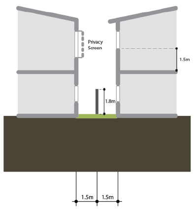  |
|
If in the Jeffery Court precinct |
|
|
PO44 Development with frontage to the foreshore must be generally consistent with Diagram 6.2.21.3.1—Jeffery Court precinct plan through including the following elements:
|
No acceptable outcome is nominated. |
Diagram 6.2.21.3.1 — Jeffery Court precinct plan
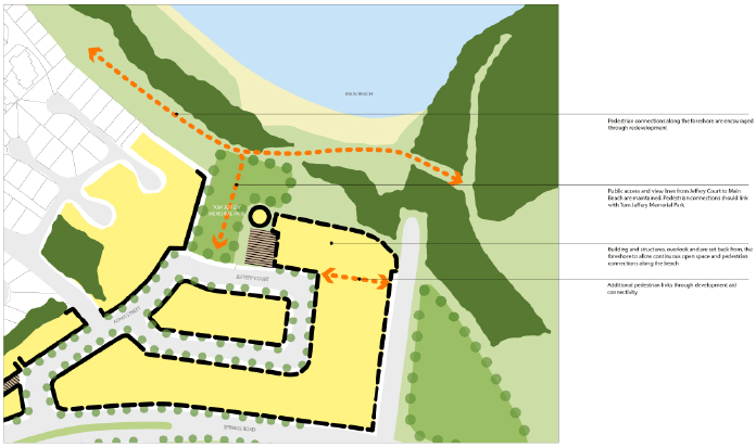
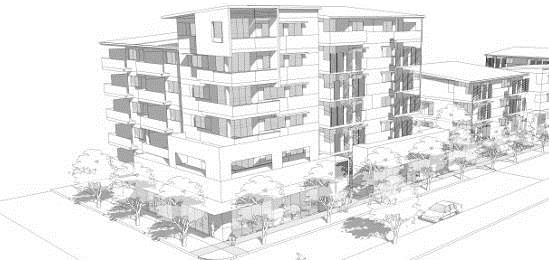
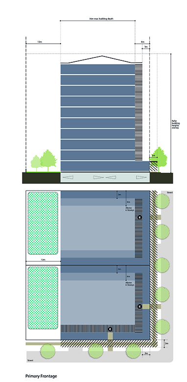
Figure 1—Primary frontage building
This building type can accommodate a diversity of land uses at higher intensities while still maintaining human scale at street level. Buildings are built to their front alignment allowing a range of finer grain uses such as shops and cafes to define main streets such as Goondoon Street and public spaces. A single storey podium defines the base of the buildings.
| Element | Acceptable solutions | ||
|---|---|---|---|
| 1.1 | Minimum frontage | 30m | |
| 1.2 | Minimum area | 1,500m2 | |
| 1.3 | Maximum building depth from the main street frontage | 36m to OMP including podium. | |
| 1.4 | Residential open space | Minimum private open space of 16m2 per dwelling with a minimum dimension of 3m in any direction. | |
| Minimum communal open space of 20% of the site area with a minimum dimension of 5m in any direction. | |||
| 1.5 | Minimum setbacks | Podium (in all directions) | 0m where abutting an existing podium or non–residential building. |
| | 3m where adjoining a residential zone. | ||
| Front [1] | 6m to main face of building (3m OMP in articulation zone [2]). | ||
| Rear [3] | 12m to OMP. | ||
| Side |
Levels 2–6: 3m to OMP Levels 7+: 6m to OMP (9m where balconies overlook side boundary in any circumstance). |
||
  Print PDF version |
|||
Diagram 6.2.21.3.2—Primary and rear frontage
Where a site located on a primary frontage has front and rear street frontages, the building treatment will be in accordance with the intent of this diagram as follows:
- The podium extends across the entire depth of the site.
- Car parking areas within the podium or basement are not permitted to extend to any street frontage and must be sleeved by the requisite frontage treatment for at least the full height of the podium or two storeys whichever is the greater.
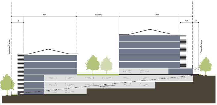
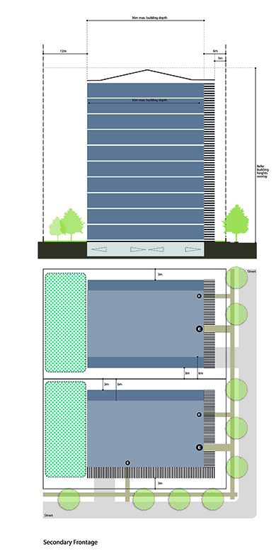
Figure 2—Secondary frontage building
This building type occurs generally on those streets in centres and mixed use areas where buildings are not required to provide active uses at ground level. These buildings may be single use commercial or residential buildings or vertically mixed use.
| Element | Acceptable solutions | ||
|---|---|---|---|
| 2.1 | Minimum frontage | 30m | |
| 2.2 | Minimum area | 1,500m2 | |
| 2.3 | Maximum building depth from the main street frontage | 36m to OMP | |
| 2.4 | Residential open space | Minimum private open space of 16m2 per dwelling with a minimum dimension of 3m in any direction. | |
| Minimum communal open space of 20% of the site area with a minimum dimension of 5m in any direction. | |||
| 2.5 | Minimum setbacks | Front | 6m to main face of building (3m OMP in articulation zone [2]). |
| Rear | 12m to OMP. | ||
| Side |
Levels 1–6: 3m to OMP Levels 7+: 6m to OMP (9m where balconies overlook side boundary in any circumstance). |
||
 Print PDF version |
|||
[1] Setback above podium level.
[2] Area from the main face of the building to the outermost projection where elements such as sun shading, balconies, roofs, eaves and overhangs project to assist in articulating the façade.
[3] The rear boundary is opposite the primary frontage of the site.


