• Skip to content
  • Skip to navigation
Print header
X

  • (07) 4970 0700
  • Online Services

«Back to
Gladstone Regional Council

Version 2 - Current Planning Scheme

  • Citation and commencement
  • Part 1 About the planning scheme
      BackPart 1 About the planning scheme
    • 1.1 Introduction
    • 1.2 Planning scheme components
    • 1.3 Interpretation
    • 1.4 Categories of development
    • 1.5 Hierarchy of assessment benchmarks
    • 1.6 Building work regulated under the planning scheme
    • 1.7 Local government administrative matters
  • Part 2 State planning provisions
      BackPart 2 State planning provisions
    • 2.1 State planning policy
    • 2.2 Regional plan
    • 2.3 Referral agency delegations
    • 2.4 Regulated requirements
  • Part 3 Strategic framework
      BackPart 3 Strategic framework
    • 3.1 Preliminary
    • 3.2 Strategic intent Open
        Back3.2 Strategic intent
      • The Gladstone Region Places Model
    • 3.3 Gateway to the world
    • 3.4 Community living
    • 3.5 Connecting our places
    • 3.6 Building it better: our urban areas
    • 3.7 Our environment and heritage
    • 3.8 Our rural and coastal townships and places
  • Part 4 Local Government Infrastructure Plan (LGIP)
      BackPart 4 Local Government Infrastructure Plan (LGIP)
    • 4.1 Preliminary
    • ​4.2 Planning assumptions Open
        Back​4.2 Planning assumptions
      • 4.2.1 Purpose
      • ​​4.2.2 Population and employment growth
      • ​4.2.3 Priority infrastructure area
      • ​​4.2.4 Desired standards of service
      • 4.2.5 Plans for trunk infrastructure
      • 4.2.7 Schedules of works
      • 4.2.8 Extrinsic material
  • Part 5 Tables of assessment
      BackPart 5 Tables of assessment
    • 5.1 Preliminary
    • 5.2 Reading the tables
    • 5.3 Categories of development and assessment
    • 5.4 Regulated categories of development and categories of assessment prescribed by the Regulation
    • 5.5 Categories of development and assessment—Material change of use Open
        Back5.5 Categories of development and assessment—Material change of use
      • 5.5.1 Low density residential zone
      • 5.5.2 Low-medium density residential zone
      • 5.5.3 Medium density residential zone
      • 5.5.4 Character residential zone
      • 5.5.5 Emerging community zone
      • 5.5.6 Mixed use zone
      • 5.5.7 Centre zone
      • 5.5.8 Principal centre zone
      • 5.5.9 Neighbourhood centre zone
      • 5.5.10 Specialised centre zone
      • 5.5.11 Low impact industry zone
      • 5.5.12 Medium impact industry zone
      • 5.5.13 Special industry zone
      • 5.5.14 Industry investigation zone
      • 5.5.15 Special purpose zone
      • 5.5.16 Rural zone
      • 5.5.17 Rural residential zone
      • 5.5.18 Township zone
      • 5.5.19 Major tourism zone
      • 5.5.20 Minor tourism zone
      • 5.5.21 Community facilities zone
      • 5.5.22 Sport and recreation zone
      • 5.5.23 Open space zone
      • 5.5.24 Environmental management zone
      • 5.5.25 Conservation zone
      • 5.5.26 Limited development zone (constrained land)
    • 5.6 Categories of development and assessment: Reconfiguring a lot
    • 5.7 Categories of development and assessment: Building work
    • 5.8 Categories of development and assessment: Operational work
    • 5.9 Categories of development and assessment: Local plans
    • 5.10 Categories of development and assessment: Overlays
  • Part 6 Zones
      BackPart 6 Zones
    • 6.2 Zone codes
        Back6.2 Zone codes
      • 6.2.1 Low density residential
      • 6.2.2 Low–medium density residential
      • 6.2.3 Medium density residential
      • 6.2.4 Character residential
      • 6.2.5 Centre
      • 6.2.6 Principal centre
      • 6.2.7 Neighbourhood centre
      • 6.2.8 Sport and recreation
      • 6.2.9 Open space
      • 6.2.10 Environmental management
      • 6.2.11 Conservation
      • 6.2.12 Low impact industry
      • 6.2.13 Medium impact industry
      • 6.2.14 Special industry
      • 6.2.15 Industry investigation
      • 6.2.16 Major tourism
      • 6.2.17 Minor tourism
      • 6.2.18 Community facilities
      • 6.2.19 Emerging community
      • 6.2.20 Limited development
      • 6.2.21 Mixed use
      • 6.2.22 Rural
      • 6.2.23 Rural residential
      • 6.2.24 Special purpose
      • 6.2.25 Specialised centre
      • 6.2.26 Township
  • Part 7 Local plans
  • Part 8 Overlays
      BackPart 8 Overlays
    • 8.2 Overlay codes Open
        Back8.2 Overlay codes
      • 8.2.1 Acid sulfate soils
      • 8.2.2 Airport environs
      • 8.2.3 Biodiversity
      • 8.2.4 Bushfire hazard
      • 8.2.5 Coastal hazard
      • 8.2.6 Extractive resources and minerals
      • 8.2.7 Flood hazard
      • 8.2.8 Hazardous activities
      • 8.2.9 Heritage
      • 8.2.10 Regional infrastructure
      • 8.2.11 Scenic amenity
      • 8.2.12 Steep land
      • 8.2.13 Water resource catchment
  • Part 9 Development codes
      BackPart 9 Development codes
    • 9.2 Development that cannot be made assessable in accordance with Schedule 6 of the Planning Regulation 2017
    • 9.3 Use codes Open
        Back9.3 Use codes
      • 9.3.1 Advertising devices
      • 9.3.2 Development design
      • 9.3.3 Extractive industry
      • 9.3.4 Home based business
      • 9.3.5 Landscaping
      • 9.3.6 Operational works
      • 9.3.7 Reconfiguring a lot
      • 9.3.8 Telecommunications facility use
  • Part 10 Other plans
  • Schedule 1 Definitions
      BackSchedule 1 Definitions
    • SC1.1 Use definitions Open
        BackSC1.1 Use definitions
      • SC1.1.1 Defined activity groups
      • SC1.1.2 Industry thresholds
      • Table Sc1.1.1—Index of use definitions
    • SC1.2 Administrative definitions
  • Schedule 2 Mapping
  • Schedule 3 Local Government Infrastructure Plan (LGIP) mapping and tables
      BackSchedule 3 Local Government Infrastructure Plan (LGIP) mapping and tables
    • SC3.1 Planning assumptions tables
    • SC3.2 Schedules of works
    • SC3.3 Local government infrastructure plan maps​
    • SC3.4 Glossary and abbreviations
  • Schedule 4 Notations required under the Planning Act 2016
  • Schedule 5 Land designated for community infrastructure
  • Schedule 6 Planning scheme policies
      BackSchedule 6 Planning scheme policies
    • SC6.1 Planning scheme policy index
    • SC6.2 Engineering design
    • SC6.3 Plans of development
    • SC6.4​ Community and economic needs assessment
    • SC6.5​ CBD redevelopment
    • SC6.6​ Beecher/Burua constant flow precinct
    • SC6.7 Flood hazard
    • SC6.8 Heritage
    • SC6.9 Non–resident workers accommodation
    • SC6.10 Vehicle parking rates
    • SC6.11 Waste management
  • Appendices
Version 2 - Current Planning Scheme
  1. Home
  2. Version 2 - Current Planning Scheme
  3. Part 6 Zones
  4. 6.2 Zone codes
  5. 6.2.7 Neighbourhood centre
Back
Online Mapping

6.2.7 Neighbourhood centre

6.2.7.1 Application

This code applies to development where the code is identified as applicable in a table of assessment.

When using this code, reference should be made to section 5.3.2 and where applicable, section 5.3.3 located in Part 5.

6.2.7.2 Purpose

  1. The purpose of the Neighbourhood Centre zone code is to provide for a small mix of land uses to service residential neighbourhoods. It includes small–scale convenience shopping, professional offices, community services and other uses that directly support the immediate community. Development in this zone must:
    1. Provide for accessible, convenient and attractive retail, commercial, administrative and community activities at a scale that does not compromise the viability of the Principal centre zone or the Centre zones.
    2. Provide for clusters of non–residential uses surrounded by residential areas that provide a mix of uses to support the day to day convenience and community needs of surrounding residents.
    3. Manage the interface between centre activities and adjoining residential activities.
    4. Promote high quality centre design that maximises access by active and public transport and activates streets and public spaces.
  2. The purpose of the zone will be achieved through the following overall outcomes:
    1. Small–scale convenience retail, commercial and community uses servicing the local community are provided. Large format retail uses are not supported in this zone.
    2. Limited residential uses such as dwelling units can occur in conjunction with centre activities.
    3. Limited after hours activities are supported where compatible with surrounding residential activities.
    4. Development is designed to incorporate sustainable practices including maximising energy efficiency, water conservation and public/active transport use.
    5. Development provides a high level of amenity and is reflective of the surrounding character of the area.
    6. Development encourages public transport accessibility and use, walking and cycling.
    7. Development has access to development infrastructure and essential services.
    8. Development responds to land constraints, including but not limited to topography, bushfire and flooding.
    9. Natural features such as creeks, gullies, waterways, wetlands, habitats, vegetation and bushland are retained, enhanced and buffered from the impacts of adjacent uses and any unavoidable impacts are minimised through location, design, operation and management requirements.

6.2.7.3 Assessment benchmarks

Table 6.2.7.3.1—Accepted development subject to requirements and assessable development

Performance outcomes Acceptable outcomes

Use – Caretaker's accommodation

PO1

Development:

  1. is ancillary to the primary use
  2. provides adequate private open space for the caretaker
  3. does not compromise ground level business activities being established.

AO1.1

No more than 1 caretaker's accommodation unit is established on the site.

AO1.2

Caretaker's accommodation is a maximum of 100m2 GFA.

AO1.3

Caretaker's accommodation is located above the ground floor level, or to the rear of ground level business activities

AO1.4

Caretaker's accommodation is provided with a private open space area which:

  1. is directly accessible from a habitable room, and
  2. where a balcony, a verandah or a deck, has a minimum area of 15m2 with a minimum horizontal dimension of 1.25m.
Use – Dwelling unit

PO2

Development does not compromise ground level business activities being established.

AO2

Dwelling units are located either above the ground floor level, or to the rear of ground level business activities.

PO3

Development must provide sufficient and accessible open space for residents needs.

AO3

Development provides a minimum of 16m2 private open space for each dwelling with a minimum dimension of 3m in any direction.

Uses – Food and drink outlet and Club

PO4

Hours of operation are limited to minimise nuisance to any surrounding residential uses.

AO4

Hours of operation are limited to between 7am and 10pm.

Use – Sales office

PO5

The use does not adversely impact on the amenity of the surrounding land uses and local character.

AO5.1

Development of the sales office is in place for no more than 2 years.

AO5.2

There are a maximum of 2 employees on site at any one time.

Scale

PO6

Retail, commercial and community based development:

  1. occurs at a scale which provides for the day to day convenience needs of neighbourhood residents in the surrounding neighbourhood
  2. does not impact on the viability of the region's other centres
  3. does not include large format, land consumptive commercial uses.

AO6.1

The combined area of the neighbourhood centre including all existing and proposed shops, offices, service industries, health care services and food and drink outlets does not exceed a total GFA of 1,500m2.

Note—This acceptable outcome does not apply if only involving the reuse of an existing building.

AO6.2

GFA of the following uses does not exceed:

  1. 1,000m2 for Shop
  2. 250m2 for Health care services
  3. 150m2 for:
    1. Adult store
    2. Car wash
    3. Club
    4. Community care centre
    5. Community use
    6. Educational establishment
    7. Food and drink outlet
    8. Function facility
    9. Funeral parlour
    10. Garden centre
    11. Hardware and trade supplies
    12. Indoor sport and recreation
    13. Market
    14. Office
    15. Place of worship
    16. Service industry
    17. Veterinary services
For all assessable development ​

​Building height (if involving building work)

​PO7

Building height:

  1. is low rise
  2. protects residential amenity through minimising overshadowing and overlooking where adjoining an existing residential use or residential zone, and
  3. does not result in a significant loss of visual amenity.

AO7

Building height does not exceed 8.5m 

Land use and tenancy mix ​

PO8

Development provides for a range of small scale retail, commercial, community, entertainment and recreation activities through a mix of building types and tenancy sizes.

No acceptable outcome is nominated.

Centre design ​

PO9

Development:

  1. is proportionate to the size and street frontage of the site
  2. maintains and enhances the existing streetscape
  3. protects adjacent residential amenity
  4. maintains appropriate levels of light and solar penetration, air circulation, privacy for adjoining properties
  5. provides for public space and landscape areas, and
  6. reduces building bulk.
No acceptable outcome is nominated.

PO10

Buildings are designed to:

  1. overlook the external street network by having buildings built up to or close to street alignments and providing active building frontages to public streets and spaces
  2. respect and complement the existing character of the area
  3. maintain an appropriate human scale
  4. minimise the use of highly reflective materials, and
  5. respond to climatic conditions.
No acceptable outcome is nominated.

PO11

Design elements contribute to an interesting and attractive streetscape and building through:

  1. variations in material and building form to enable articulation of facades and differentiation between buildings
  2. modulation in the façade, horizontally or vertically
  3. articulation of building entrances and openings
  4. corner treatments to address both street frontages, and
  5. elements which assist in wayfinding and legibility.
No acceptable outcome is nominated.

PO12

Building caps and rooftops contribute to the architectural distinction of the building, and effectively screen service structures, lift over–runs, plant and equipment.

No acceptable outcome is nominated.

PO13

Development is designed to facilitate the safety and security of people and property having regard to:

  1. maximising casual surveillance and sight lines
  2. exterior building design that promotes safety
  3. adequate lighting
  4. appropriate signage and wayfinding
  5. minimisation of personal concealment and entrapment locations, and
  6. building entrances, parking, loading and storage areas that are well lit and have clearly defined access points.

Note—Applicants should have regard to Crime Prevention through Environmental Design Guidelines for Queensland.

No acceptable outcome is nominated.
Street interface

PO14

Buildings are oriented to address all street frontages, public open space and public areas to:

  1. promote interaction and casual surveillance
  2. concentrate and reinforce pedestrian activity
  3. create consolidated street edges
  4. avoid opaque facades to provide visual interest to the frontage, and
  5. clearly define the public realm.
No acceptable outcome is nominated.

PO15

Buildings and pedestrian entries:

  1. are visible from the street and car parking areas
  2. incorporate sun and rain shelter, such as overhangs or awnings, and
  3. are defined by design elements (such as doors and landscaping, etc.)
No acceptable outcome is nominated.

PO16

Buildings includes windows and openings to:

  1. promote street life and business activities
  2. encourage strong indoor/outdoor relationships at ground level, and
  3. to facilitate casual surveillance.
No acceptable outcome is nominated.

PO17

Development contributes towards high quality streetscape outcomes that integrate effectively with the street and along key pedestrian and cycle routes.

No acceptable outcome is nominated.

PO18

Buildings include awnings that:

  1. complement and integrate with the front building façade
  2. protect street footpaths from rain and sun
  3. are continuous and compatible with existing pedestrian shelter and awnings on adjoining buildings
  4. allow for street trees and other landscaping
  5. are visually safe and amenable
  6. are cantilevered from the main building and do not include posts within the footpath, and
  7. are constructed of lightweight materials.
No acceptable outcome is nominated.

PO19

Development must ensure safe, convenient and legible connections and pathways are provided:

  1. for pedestrians and cyclists to, from and within the site
  2. to public transport infrastructure, open space, parkland, centres and community–related activities.
No acceptable outcome is nominated.
Landscape design

PO20

Landscape elements are integrated in the building design through planting at various levels including on top of podiums, rooftops and within storeys.

Note—Refer also to the Landscaping code.

No acceptable outcome is nominated.

PO21

Landscape treatments includes hard and soft elements that:

  1. is of a character and durability that reflects the centre
  2. enhance the appearance of the centre
  3. extends from the street edge into building entrances, foyers and onto podiums
  4. emphasises a clear pedestrian entry point
  5. screen unsightly components
  6. provide shading, and
  7. reflects and reinforces a subtropical image through integrating landscape, outdoor and indoor spaces.

Note—Refer also to the Landscaping code.

No acceptable outcome is nominated.
Amenity

PO22

Development is located, designed and operated so that adverse impacts on privacy and amenity on nearby land in a residential zone are minimised.

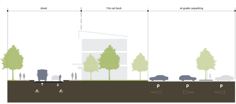
AO22.1

Buildings are set back 3m from any boundary shared with a residential zone.

AO22.2

A 1.8m high solid screen fence is provided along all boundaries shared with a residential zone.

AO22.3

A landscaped buffer with a minimum width of 2m and consisting of dense screen planting is provided along all boundaries shared with a residential zone.

AO22.4

Windows that have a direct view into an adjoining residential use are provided with fixed screening that is a maximum of 50% transparent to obscure views and maintain privacy for residents.

PO23

Development minimises impacts on surrounding land and provides for an appropriate level of amenity within the centre, having regard to:

  1. noise
  2. hours of operation
  3. traffic
  4. visual impact
  5. signage
  6. odour and emissions
  7. lighting
  8. access to sunlight
  9. privacy, and
  10. outlook.

Note—Applicants may be required to engage specialists to provide detailed investigations into the above matters in order to demonstrate compliance with this performance criterion.

No acceptable outcome is nominated.

PO24

All uses are located, designed, orientated and constructed to:

  1. minimise noise dust, odour or other nuisance from existing lawful uses, and
  2. minimise nuisance caused by noise, vibration and dust emissions generated by the state–controlled road and rail network in the vicinity.
No acceptable outcome is nominated.
Car parking and access

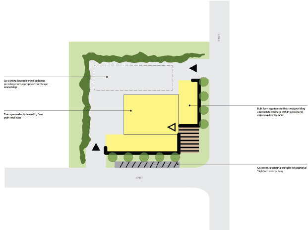
PO25

Parking and loading areas do not visually dominate the streetscape.

AO25.1

Parking areas are:

  1. located in a basement or semi basement, or
  2. setback a minimum of 15m from any street frontage and screened to allow a building edge for active uses.

Note—Refer also to Diagram 6.2.7.3.1—Parking design in neighbourhood centres.

AO25.2

Vehicle loading areas are screened from footpaths, streets and public areas by fences with screening at least 1.5m in height and are 50% visually permeable.

Storage areas ​

PO26

Ancillary storage of goods or materials must be located in a manner that does not detract from the visual amenity of the local area.

AO26

Equipment, materials, goods and/or, machinery used on site are either:

  1. stored behind the front building setback and screened from view, or
  2. stored within a building.

Effects of development ​

PO27

Development responds sensitively to on–site and surrounding topography, coastal foreshores, waterways, drainage patterns, utility services, access, vegetation and adjoining land use, such that:

  1. any hazards to people or property are avoided
  2. any earthworks are minimised
  3. the retention of natural drainage line is maximised
  4. the retention of existing vegetation is maximised
  5. damage or disruption to sewerage, stormwater and water infrastructure is avoided, and
  6. there is adequate buffering, screening or separation to adjoining development.
No acceptable outcome is nominated.

Use – Child care centre ​

PO28

Development is:

  1. compatible with neighbouring uses
  2. complementary to local character and amenity
  3. supports the day to day needs of residents
  4. located on a site which must adequately accommodate activity needs and space requirements.
No acceptable outcome is nominated.

PO29

Where adjoining a residential use or land in the residential zone, development must ensure residential amenity is maintained on adjoining properties.

AO29.1

Development provides a 1.8m acoustic screen fence where adjoining a residential use.

AO29.2

Hours of operation are limited to between 6am and 7pm daily.

PO30

Development minimises:

  1. the hazards of heavy traffic
  2. introduction of non–local traffic into minor, residential streets, and
  3. on–site conflict between children's activities, pedestrian movement, vehicle movement and car parking.
​

AO30.1

The use is not accessed from:

  1. arterial/sub–arterial routes, or
  2. an access street or access place.

AO30.2

Parking spaces are located so that children are not required to cross the driveway or vehicular access way to reach the building.


Diagram 6.2.7.3.1—Parking design in neighbourhood centres

6.2.5.3.1 Parkingdesign example1

Example 1—Correct parking treatment​

Print PDF version

130909 Centre 07 neighbourhood centre 5000

Print PDF version

Online Mapping

Version 2 - Current Planning Scheme

SELECT
  • Citation and commencement
  • Part 1 About the planning scheme
      BackPart 1 About the planning scheme
    • 1.1 Introduction
    • 1.2 Planning scheme components
    • 1.3 Interpretation
    • 1.4 Categories of development
    • 1.5 Hierarchy of assessment benchmarks
    • 1.6 Building work regulated under the planning scheme
    • 1.7 Local government administrative matters
  • Part 2 State planning provisions
      BackPart 2 State planning provisions
    • 2.1 State planning policy
    • 2.2 Regional plan
    • 2.3 Referral agency delegations
    • 2.4 Regulated requirements
  • Part 3 Strategic framework
      BackPart 3 Strategic framework
    • 3.1 Preliminary
    • 3.2 Strategic intent Open
        Back3.2 Strategic intent
      • The Gladstone Region Places Model
    • 3.3 Gateway to the world
    • 3.4 Community living
    • 3.5 Connecting our places
    • 3.6 Building it better: our urban areas
    • 3.7 Our environment and heritage
    • 3.8 Our rural and coastal townships and places
  • Part 4 Local Government Infrastructure Plan (LGIP)
      BackPart 4 Local Government Infrastructure Plan (LGIP)
    • 4.1 Preliminary
    • ​4.2 Planning assumptions Open
        Back​4.2 Planning assumptions
      • 4.2.1 Purpose
      • ​​4.2.2 Population and employment growth
      • ​4.2.3 Priority infrastructure area
      • ​​4.2.4 Desired standards of service
      • 4.2.5 Plans for trunk infrastructure
      • 4.2.7 Schedules of works
      • 4.2.8 Extrinsic material
  • Part 5 Tables of assessment
      BackPart 5 Tables of assessment
    • 5.1 Preliminary
    • 5.2 Reading the tables
    • 5.3 Categories of development and assessment
    • 5.4 Regulated categories of development and categories of assessment prescribed by the Regulation
    • 5.5 Categories of development and assessment—Material change of use Open
        Back5.5 Categories of development and assessment—Material change of use
      • 5.5.1 Low density residential zone
      • 5.5.2 Low-medium density residential zone
      • 5.5.3 Medium density residential zone
      • 5.5.4 Character residential zone
      • 5.5.5 Emerging community zone
      • 5.5.6 Mixed use zone
      • 5.5.7 Centre zone
      • 5.5.8 Principal centre zone
      • 5.5.9 Neighbourhood centre zone
      • 5.5.10 Specialised centre zone
      • 5.5.11 Low impact industry zone
      • 5.5.12 Medium impact industry zone
      • 5.5.13 Special industry zone
      • 5.5.14 Industry investigation zone
      • 5.5.15 Special purpose zone
      • 5.5.16 Rural zone
      • 5.5.17 Rural residential zone
      • 5.5.18 Township zone
      • 5.5.19 Major tourism zone
      • 5.5.20 Minor tourism zone
      • 5.5.21 Community facilities zone
      • 5.5.22 Sport and recreation zone
      • 5.5.23 Open space zone
      • 5.5.24 Environmental management zone
      • 5.5.25 Conservation zone
      • 5.5.26 Limited development zone (constrained land)
    • 5.6 Categories of development and assessment: Reconfiguring a lot
    • 5.7 Categories of development and assessment: Building work
    • 5.8 Categories of development and assessment: Operational work
    • 5.9 Categories of development and assessment: Local plans
    • 5.10 Categories of development and assessment: Overlays
  • Part 6 Zones
      BackPart 6 Zones
    • 6.2 Zone codes
        Back6.2 Zone codes
      • 6.2.1 Low density residential
      • 6.2.2 Low–medium density residential
      • 6.2.3 Medium density residential
      • 6.2.4 Character residential
      • 6.2.5 Centre
      • 6.2.6 Principal centre
      • 6.2.7 Neighbourhood centre
      • 6.2.8 Sport and recreation
      • 6.2.9 Open space
      • 6.2.10 Environmental management
      • 6.2.11 Conservation
      • 6.2.12 Low impact industry
      • 6.2.13 Medium impact industry
      • 6.2.14 Special industry
      • 6.2.15 Industry investigation
      • 6.2.16 Major tourism
      • 6.2.17 Minor tourism
      • 6.2.18 Community facilities
      • 6.2.19 Emerging community
      • 6.2.20 Limited development
      • 6.2.21 Mixed use
      • 6.2.22 Rural
      • 6.2.23 Rural residential
      • 6.2.24 Special purpose
      • 6.2.25 Specialised centre
      • 6.2.26 Township
  • Part 7 Local plans
  • Part 8 Overlays
      BackPart 8 Overlays
    • 8.2 Overlay codes Open
        Back8.2 Overlay codes
      • 8.2.1 Acid sulfate soils
      • 8.2.2 Airport environs
      • 8.2.3 Biodiversity
      • 8.2.4 Bushfire hazard
      • 8.2.5 Coastal hazard
      • 8.2.6 Extractive resources and minerals
      • 8.2.7 Flood hazard
      • 8.2.8 Hazardous activities
      • 8.2.9 Heritage
      • 8.2.10 Regional infrastructure
      • 8.2.11 Scenic amenity
      • 8.2.12 Steep land
      • 8.2.13 Water resource catchment
  • Part 9 Development codes
      BackPart 9 Development codes
    • 9.2 Development that cannot be made assessable in accordance with Schedule 6 of the Planning Regulation 2017
    • 9.3 Use codes Open
        Back9.3 Use codes
      • 9.3.1 Advertising devices
      • 9.3.2 Development design
      • 9.3.3 Extractive industry
      • 9.3.4 Home based business
      • 9.3.5 Landscaping
      • 9.3.6 Operational works
      • 9.3.7 Reconfiguring a lot
      • 9.3.8 Telecommunications facility use
  • Part 10 Other plans
  • Schedule 1 Definitions
      BackSchedule 1 Definitions
    • SC1.1 Use definitions Open
        BackSC1.1 Use definitions
      • SC1.1.1 Defined activity groups
      • SC1.1.2 Industry thresholds
      • Table Sc1.1.1—Index of use definitions
    • SC1.2 Administrative definitions
  • Schedule 2 Mapping
  • Schedule 3 Local Government Infrastructure Plan (LGIP) mapping and tables
      BackSchedule 3 Local Government Infrastructure Plan (LGIP) mapping and tables
    • SC3.1 Planning assumptions tables
    • SC3.2 Schedules of works
    • SC3.3 Local government infrastructure plan maps​
    • SC3.4 Glossary and abbreviations
  • Schedule 4 Notations required under the Planning Act 2016
  • Schedule 5 Land designated for community infrastructure
  • Schedule 6 Planning scheme policies
      BackSchedule 6 Planning scheme policies
    • SC6.1 Planning scheme policy index
    • SC6.2 Engineering design
    • SC6.3 Plans of development
    • SC6.4​ Community and economic needs assessment
    • SC6.5​ CBD redevelopment
    • SC6.6​ Beecher/Burua constant flow precinct
    • SC6.7 Flood hazard
    • SC6.8 Heritage
    • SC6.9 Non–resident workers accommodation
    • SC6.10 Vehicle parking rates
    • SC6.11 Waste management
  • Appendices

Gladstone Regional Council

Connect. Innovate. Diversify.

Return to top

Get in Touch

Phone

(07) 4970 0700

Opening Hours

8.30am - 5pm Monday to Friday

Social media

Contact Us  Email Us

Postal Address

PO Box 29, Gladstone Qld 4680

Council Offices

101 Goondoon Street, Gladstone Qld 4680
3 Don Cameron Drive, Calliope Qld 4680
41 Blomfield Street, Miriam Vale Qld 4677
Cnr Wyndham & Hayes Avenues, Boyne Island Qld 4680

Rural Transaction Centres

71 Springs Road, Agnes Water Qld 4677
47 Raglan Street, Mount Larcom Qld 4695

Footer Image Links

Gladstone Regional Council Logor Gladstone Entertainment Convention Centre Logo Gladstone Regional Art Gallery and Museum Logo Gladstone Regional Libraries Logo Gladstone Tondoon Botanic Gardens Logo Philip Street Communities and Families Precinct

Footer Acknowledgement

Gladstone Regional Council would like to acknowledge the Bailai, the Gurang, the Gooreng Gooreng and the Taribelang Bunda people who are the traditional custodians of this land. Gladstone Regional Council would also like to pay respect to Elders both past, present and emerging, and extend that respect to other Aboriginal and Torres Strait Islander people. Learn more about Council's Reconciliation Action Plan (RAP).

Chat Popup

Launch Chat

© 2025 Gladstone Regional Council

All content © Gladstone Regional Council Planning Scheme. All Rights Reserved.

Powered by Jadu Central.

  • Privacy
  • Right to Information
  • Login
Back to the top
Print footer