• Skip to content
  • Skip to navigation
Print header
X

  • (07) 4970 0700
  • Online Services

«Back to
Gladstone Regional Council

Version 2 - Current Planning Scheme

  • Citation and commencement
  • Part 1 About the planning scheme
      BackPart 1 About the planning scheme
    • 1.1 Introduction
    • 1.2 Planning scheme components
    • 1.3 Interpretation
    • 1.4 Categories of development
    • 1.5 Hierarchy of assessment benchmarks
    • 1.6 Building work regulated under the planning scheme
    • 1.7 Local government administrative matters
  • Part 2 State planning provisions
      BackPart 2 State planning provisions
    • 2.1 State planning policy
    • 2.2 Regional plan
    • 2.3 Referral agency delegations
    • 2.4 Regulated requirements
  • Part 3 Strategic framework
      BackPart 3 Strategic framework
    • 3.1 Preliminary
    • 3.2 Strategic intent Open
        Back3.2 Strategic intent
      • The Gladstone Region Places Model
    • 3.3 Gateway to the world
    • 3.4 Community living
    • 3.5 Connecting our places
    • 3.6 Building it better: our urban areas
    • 3.7 Our environment and heritage
    • 3.8 Our rural and coastal townships and places
  • Part 4 Local Government Infrastructure Plan (LGIP)
      BackPart 4 Local Government Infrastructure Plan (LGIP)
    • 4.1 Preliminary
    • ​4.2 Planning assumptions Open
        Back​4.2 Planning assumptions
      • 4.2.1 Purpose
      • ​​4.2.2 Population and employment growth
      • ​4.2.3 Priority infrastructure area
      • ​​4.2.4 Desired standards of service
      • 4.2.5 Plans for trunk infrastructure
      • 4.2.7 Schedules of works
      • 4.2.8 Extrinsic material
  • Part 5 Tables of assessment
      BackPart 5 Tables of assessment
    • 5.1 Preliminary
    • 5.2 Reading the tables
    • 5.3 Categories of development and assessment
    • 5.4 Regulated categories of development and categories of assessment prescribed by the Regulation
    • 5.5 Categories of development and assessment—Material change of use Open
        Back5.5 Categories of development and assessment—Material change of use
      • 5.5.1 Low density residential zone
      • 5.5.2 Low-medium density residential zone
      • 5.5.3 Medium density residential zone
      • 5.5.4 Character residential zone
      • 5.5.5 Emerging community zone
      • 5.5.6 Mixed use zone
      • 5.5.7 Centre zone
      • 5.5.8 Principal centre zone
      • 5.5.9 Neighbourhood centre zone
      • 5.5.10 Specialised centre zone
      • 5.5.11 Low impact industry zone
      • 5.5.12 Medium impact industry zone
      • 5.5.13 Special industry zone
      • 5.5.14 Industry investigation zone
      • 5.5.15 Special purpose zone
      • 5.5.16 Rural zone
      • 5.5.17 Rural residential zone
      • 5.5.18 Township zone
      • 5.5.19 Major tourism zone
      • 5.5.20 Minor tourism zone
      • 5.5.21 Community facilities zone
      • 5.5.22 Sport and recreation zone
      • 5.5.23 Open space zone
      • 5.5.24 Environmental management zone
      • 5.5.25 Conservation zone
      • 5.5.26 Limited development zone (constrained land)
    • 5.6 Categories of development and assessment: Reconfiguring a lot
    • 5.7 Categories of development and assessment: Building work
    • 5.8 Categories of development and assessment: Operational work
    • 5.9 Categories of development and assessment: Local plans
    • 5.10 Categories of development and assessment: Overlays
  • Part 6 Zones
      BackPart 6 Zones
    • 6.2 Zone codes
        Back6.2 Zone codes
      • 6.2.1 Low density residential
      • 6.2.2 Low–medium density residential
      • 6.2.3 Medium density residential
      • 6.2.4 Character residential
      • 6.2.5 Centre
      • 6.2.6 Principal centre
      • 6.2.7 Neighbourhood centre
      • 6.2.8 Sport and recreation
      • 6.2.9 Open space
      • 6.2.10 Environmental management
      • 6.2.11 Conservation
      • 6.2.12 Low impact industry
      • 6.2.13 Medium impact industry
      • 6.2.14 Special industry
      • 6.2.15 Industry investigation
      • 6.2.16 Major tourism
      • 6.2.17 Minor tourism
      • 6.2.18 Community facilities
      • 6.2.19 Emerging community
      • 6.2.20 Limited development
      • 6.2.21 Mixed use
      • 6.2.22 Rural
      • 6.2.23 Rural residential
      • 6.2.24 Special purpose
      • 6.2.25 Specialised centre
      • 6.2.26 Township
  • Part 7 Local plans
  • Part 8 Overlays
      BackPart 8 Overlays
    • 8.2 Overlay codes Open
        Back8.2 Overlay codes
      • 8.2.1 Acid sulfate soils
      • 8.2.2 Airport environs
      • 8.2.3 Biodiversity
      • 8.2.4 Bushfire hazard
      • 8.2.5 Coastal hazard
      • 8.2.6 Extractive resources and minerals
      • 8.2.7 Flood hazard
      • 8.2.8 Hazardous activities
      • 8.2.9 Heritage
      • 8.2.10 Regional infrastructure
      • 8.2.11 Scenic amenity
      • 8.2.12 Steep land
      • 8.2.13 Water resource catchment
  • Part 9 Development codes
      BackPart 9 Development codes
    • 9.2 Development that cannot be made assessable in accordance with Schedule 6 of the Planning Regulation 2017
    • 9.3 Use codes Open
        Back9.3 Use codes
      • 9.3.1 Advertising devices
      • 9.3.2 Development design
      • 9.3.3 Extractive industry
      • 9.3.4 Home based business
      • 9.3.5 Landscaping
      • 9.3.6 Operational works
      • 9.3.7 Reconfiguring a lot
      • 9.3.8 Telecommunications facility use
  • Part 10 Other plans
  • Schedule 1 Definitions
      BackSchedule 1 Definitions
    • SC1.1 Use definitions Open
        BackSC1.1 Use definitions
      • SC1.1.1 Defined activity groups
      • SC1.1.2 Industry thresholds
      • Table Sc1.1.1—Index of use definitions
    • SC1.2 Administrative definitions
  • Schedule 2 Mapping
  • Schedule 3 Local Government Infrastructure Plan (LGIP) mapping and tables
      BackSchedule 3 Local Government Infrastructure Plan (LGIP) mapping and tables
    • SC3.1 Planning assumptions tables
    • SC3.2 Schedules of works
    • SC3.3 Local government infrastructure plan maps​
    • SC3.4 Glossary and abbreviations
  • Schedule 4 Notations required under the Planning Act 2016
  • Schedule 5 Land designated for community infrastructure
  • Schedule 6 Planning scheme policies
      BackSchedule 6 Planning scheme policies
    • SC6.1 Planning scheme policy index
    • SC6.2 Engineering design
    • SC6.3 Plans of development
    • SC6.4​ Community and economic needs assessment
    • SC6.5​ CBD redevelopment
    • SC6.6​ Beecher/Burua constant flow precinct
    • SC6.7 Flood hazard
    • SC6.8 Heritage
    • SC6.9 Non–resident workers accommodation
    • SC6.10 Vehicle parking rates
    • SC6.11 Waste management
  • Appendices
Version 2 - Current Planning Scheme
  1. Home
  2. Version 2 - Current Planning Scheme
  3. Part 6 Zones
  4. 6.2 Zone codes
  5. 6.2.4 Character residential
Back
Online Mapping

6.2.4 Character residential

6.2.4.1 Application

This code applies to development where the code is identified as applicable in a table of assessment. When using this code, reference should be made to section 5.3.2 and where applicable, section 5.3.3 located in Part 5.

6.2.4.2 Purpose

  1. The purpose of the character residential zone code is to ensure that development recognises and respects the important scenic and heritage character of the Town of Seventeen Seventy and the natural landscape and existing coastal development character of the Springs Beach/Red Rock area, south of Agnes Water, by supporting a built form that:
    1. Exemplifies the existing natural landscape and coastal character of these areas; and
    2. Minimises visual impacts and prevents buildings from dominating the natural landscape; and.
    3. Is interspersed and sympathetically sited amongst the coastal landscape and bushland elements.
  2. The purpose of the zone will be achieved through the following overall outcomes:
    1. Development recognises and protects the important scenic and heritage character by promoting the use of light-weight building materials, generous roof forms, building articulation and overhangs.
    2. Development is in the form of individual detached buildings, small–scale in size and low–rise in height.
    3. Development maximises the retention of existing native vegetation where possible.
    4. Development respects the topography of the locality by ensuring buildings follow the contours of the land and minimise disturbance of the natural ground form.
    5. Development is designed to maximise energy efficiency and water conservation.
    6. Non–residential uses may be supported where such uses provide for the day to– day needs of the immediate residential community, do not detract from the character, and do not undermine the viability of nearby centres.
    7. Small scale short term accommodation may be appropriate to support tourism activities only where in an existing building.
    8. Development responds to land constraints including topography, limited access, bushfire and flooding constraints.
    9. Development mitigates any adverse impacts on adjoining areas of environmental significance, including creeks, gullies, waterways, wetlands, coastal areas, habitats, vegetation and bushland through location, design, operation and management requirements.

6.2.4.3 Assessment benchmarks

Table 6.2.4.3.1—Accepted development subject to requirements and assessable development

Performance outcomes Acceptable outcomes
Use – Caretaker's accommodation

PO1

Development is:

  1. ancillary to the primary use, and
  2. does not compromise the low density character of the locality.

AO1.1

No more than 1 caretaker's accommodation unit is established on the site.

AO1.2

Development is a maximum of 100m2 GFA.

Built form (if involving building work)

PO2

Buildings are:

  1. low rise
  2. low density
  3. of a size and scale that ensures the built form does not dominate natural landscape values, and
  4. designed and located so as not to adversely impact on the coastal and visual character of the area.

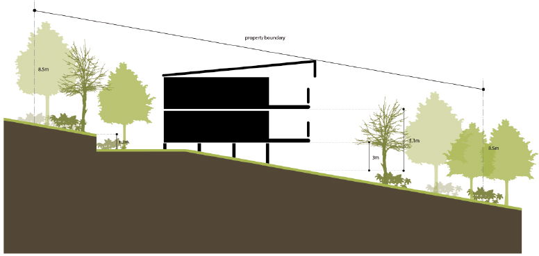
AO2.1

Building height does not:

  1. exceed 8.5m and 2 storeys, and
  2. protrude above any horizon, ridge or spur line when viewed from any place on the coastline (beach or headlands) or from the ocean.

Note—Refer also to Diagram 6.2.4.3.1—Character dwelling house.

AO2.2

The floor level of the upper most habitable level is no greater than 5.1m above ground level at any point.

Note—Refer also to Diagram 6.2.4.3.1—Character dwelling house.

AO2.3

The floor of the first habitable level including decks and verandahs is no greater than 3m above ground level at any point.

Note—Refer also to Diagram 6.2.4.3.1—Character dwelling house.

AO2.4

The maximum footprint for all buildings including any outbuildings, swimming pools or other structures is:

  1. 400m2 on lot sizes 800m2 – 1499m2, or
  2. 450m2 on lot sizes 1500m2 – 2499m2, or
  3. 500m2 on lots greater than 2500m2.

PO3

Buildings are located on the site to:

  1. to maximise the residential amenity of residents and neighbours
  2. maximise retention of native vegetation, and
  3. provide areas for landscaping to screen the building.

AO3.1

Buildings are setback a minimum of 6m from the front and rear boundaries.

Note—A carport may be built in the 6m front setback where the maximum height is 3.5m.

AO3.2

Side boundary setbacks for any building or structure are a minimum of 4m.

Note—Side boundary setbacks are measured to the building wall.

AO3.3

Where dual occupancy, dwellings are separated by a minimum of 6m.

Note—Buildings can be linked by one unenclosed verandah or walkway.

Residential density

PO4

Residential density reflects the low density character of the locality.

​

AO4.1

Residential density is a maximum of

  1. 1 Dwelling house (including 1 secondary dwelling) per allotment; or
  2. 1 dwelling unit per 400m2 where a Dual occupancy.

AO4.2

Where a dwelling house, any secondary dwelling is:

  1. a maximum of 80m2 GFA
  2. located within 50m of the main building
  3. linked to the main building by a defined footpath in the most direct route possible.
Character

PO5

Buildings reflect the coastal character of the zones through open frame architecture including verandahs/decks, eaves and the use of lightweight construction materials.

AO5.1

Buildings:

  1. include suspended floors
  2. use sheet material finishes such as timber and fibre cement for external cladding
  3. limit masonry construction so that no masonry walls exceed 4.5m above ground level and:
    1. are rendered and painted, or
    2. where constructed of local stone left unfinished; and
    3. incorporate appropriate articulation
  4. include roofing comprised of lightweight and non–reflective sheet materials.

AO5.2

Eaves extend a minimum of 0.6m from the wall.

PO6

Front fencing must:

  1. not dominate the streetscape, and
  2. complement the low density sub–tropical character of the area.

AO6

Front fences are:

  1. a maximum height of 1.5m
  2. 50% transparent
  3. made of open timber or metal construction, and
  4. do not impede existing overland flow paths.

PO7

Driveways, cross overs and car parking areas:

  1. do not dominate the streetscape
  2. are located to minimise the removal of mature trees, and
  3. constructed from permeable materials where possible to maintain natural drainage flows and maximise stormwater infiltration on–site.

AO7.1

Driveways, crossovers and car parking areas are:

  1. finished with a permeable surface, and
  2. not located within 4m of the side boundary.

AO7.2

Driveways and crossovers are:

  1. a maximum of 3.5m wide including splays, and
  2. limited to 1 per lot.
Landscaping

PO8

Development and landscaping:

  1. enhances visual amenity and screen buildings from streets, walkways and other public places
  2. integrates with the natural features
  3. minimises earthworks and the use of retaining walls, and
  4. complements the low density sub–tropical character of the area.

AO8.1

Plant species used for landscaping are native to the locality.

AO8.2

Uncovered external paved or hard landscaped areas not used for car parking are limited to 36m2 where a Dwelling house or 18m2 where a dual occupancy.

AO8.3

Excavation and fill is limited to:

  1. maximum cut of 1m below ground level, and
  2. maximum fill of 1m above ground level.

AO8.4

Retaining walls and terraces are:

  1. not constructed to create a level lot
  2. a maximum 0.6m high to the street frontage, and
  3. a maximum height of 1.2m elsewhere on the lot.
For all assessable development ​
Land use

PO9

Development is of a small scale that does not compromise the low density and coastal village character of the locality.

No acceptable outcomes are nominated.

Effects of development

PO10

Development responds sensitively to on–site and surrounding topography, drainage patterns, utility services, access, vegetation and adjoining land use, such that:

  1. any hazards to people or property are avoided
  2. native plants are retained within the lot or premises and adjoining road reserve
  3. any earthworks are minimised
  4. the retention of natural drainage systems is maximised
  5. the retention of existing vegetation is maximised
  6. damage or disruption to sewerage, stormwater and water infrastructure is avoided, and
  7. there is adequate buffering, screening or separation to adjoining development.
No acceptable outcomes are nominated.

PO11

Development maintains a high level of amenity within the site and minimises impacts on surrounding areas, having regard to:

  1. noise
  2. hours of operation including temporary uses
  3. traffic and parking
  4. visual impact
  5. signage
  6. odour and emissions
  7. lighting
  8. access to sunlight
  9. privacy.

Note—Applicants may be required to engage specialists to provide detailed investigations into the above matters in order to demonstrate compliance with this performance criterion.

No acceptable outcome is nominated.


Diagram 6.2.4.3.1—Character dwelling house

6.2.4.3.1 Character dwelling house

Print PDF version

Online Mapping

Version 2 - Current Planning Scheme

SELECT
  • Citation and commencement
  • Part 1 About the planning scheme
      BackPart 1 About the planning scheme
    • 1.1 Introduction
    • 1.2 Planning scheme components
    • 1.3 Interpretation
    • 1.4 Categories of development
    • 1.5 Hierarchy of assessment benchmarks
    • 1.6 Building work regulated under the planning scheme
    • 1.7 Local government administrative matters
  • Part 2 State planning provisions
      BackPart 2 State planning provisions
    • 2.1 State planning policy
    • 2.2 Regional plan
    • 2.3 Referral agency delegations
    • 2.4 Regulated requirements
  • Part 3 Strategic framework
      BackPart 3 Strategic framework
    • 3.1 Preliminary
    • 3.2 Strategic intent Open
        Back3.2 Strategic intent
      • The Gladstone Region Places Model
    • 3.3 Gateway to the world
    • 3.4 Community living
    • 3.5 Connecting our places
    • 3.6 Building it better: our urban areas
    • 3.7 Our environment and heritage
    • 3.8 Our rural and coastal townships and places
  • Part 4 Local Government Infrastructure Plan (LGIP)
      BackPart 4 Local Government Infrastructure Plan (LGIP)
    • 4.1 Preliminary
    • ​4.2 Planning assumptions Open
        Back​4.2 Planning assumptions
      • 4.2.1 Purpose
      • ​​4.2.2 Population and employment growth
      • ​4.2.3 Priority infrastructure area
      • ​​4.2.4 Desired standards of service
      • 4.2.5 Plans for trunk infrastructure
      • 4.2.7 Schedules of works
      • 4.2.8 Extrinsic material
  • Part 5 Tables of assessment
      BackPart 5 Tables of assessment
    • 5.1 Preliminary
    • 5.2 Reading the tables
    • 5.3 Categories of development and assessment
    • 5.4 Regulated categories of development and categories of assessment prescribed by the Regulation
    • 5.5 Categories of development and assessment—Material change of use Open
        Back5.5 Categories of development and assessment—Material change of use
      • 5.5.1 Low density residential zone
      • 5.5.2 Low-medium density residential zone
      • 5.5.3 Medium density residential zone
      • 5.5.4 Character residential zone
      • 5.5.5 Emerging community zone
      • 5.5.6 Mixed use zone
      • 5.5.7 Centre zone
      • 5.5.8 Principal centre zone
      • 5.5.9 Neighbourhood centre zone
      • 5.5.10 Specialised centre zone
      • 5.5.11 Low impact industry zone
      • 5.5.12 Medium impact industry zone
      • 5.5.13 Special industry zone
      • 5.5.14 Industry investigation zone
      • 5.5.15 Special purpose zone
      • 5.5.16 Rural zone
      • 5.5.17 Rural residential zone
      • 5.5.18 Township zone
      • 5.5.19 Major tourism zone
      • 5.5.20 Minor tourism zone
      • 5.5.21 Community facilities zone
      • 5.5.22 Sport and recreation zone
      • 5.5.23 Open space zone
      • 5.5.24 Environmental management zone
      • 5.5.25 Conservation zone
      • 5.5.26 Limited development zone (constrained land)
    • 5.6 Categories of development and assessment: Reconfiguring a lot
    • 5.7 Categories of development and assessment: Building work
    • 5.8 Categories of development and assessment: Operational work
    • 5.9 Categories of development and assessment: Local plans
    • 5.10 Categories of development and assessment: Overlays
  • Part 6 Zones
      BackPart 6 Zones
    • 6.2 Zone codes
        Back6.2 Zone codes
      • 6.2.1 Low density residential
      • 6.2.2 Low–medium density residential
      • 6.2.3 Medium density residential
      • 6.2.4 Character residential
      • 6.2.5 Centre
      • 6.2.6 Principal centre
      • 6.2.7 Neighbourhood centre
      • 6.2.8 Sport and recreation
      • 6.2.9 Open space
      • 6.2.10 Environmental management
      • 6.2.11 Conservation
      • 6.2.12 Low impact industry
      • 6.2.13 Medium impact industry
      • 6.2.14 Special industry
      • 6.2.15 Industry investigation
      • 6.2.16 Major tourism
      • 6.2.17 Minor tourism
      • 6.2.18 Community facilities
      • 6.2.19 Emerging community
      • 6.2.20 Limited development
      • 6.2.21 Mixed use
      • 6.2.22 Rural
      • 6.2.23 Rural residential
      • 6.2.24 Special purpose
      • 6.2.25 Specialised centre
      • 6.2.26 Township
  • Part 7 Local plans
  • Part 8 Overlays
      BackPart 8 Overlays
    • 8.2 Overlay codes Open
        Back8.2 Overlay codes
      • 8.2.1 Acid sulfate soils
      • 8.2.2 Airport environs
      • 8.2.3 Biodiversity
      • 8.2.4 Bushfire hazard
      • 8.2.5 Coastal hazard
      • 8.2.6 Extractive resources and minerals
      • 8.2.7 Flood hazard
      • 8.2.8 Hazardous activities
      • 8.2.9 Heritage
      • 8.2.10 Regional infrastructure
      • 8.2.11 Scenic amenity
      • 8.2.12 Steep land
      • 8.2.13 Water resource catchment
  • Part 9 Development codes
      BackPart 9 Development codes
    • 9.2 Development that cannot be made assessable in accordance with Schedule 6 of the Planning Regulation 2017
    • 9.3 Use codes Open
        Back9.3 Use codes
      • 9.3.1 Advertising devices
      • 9.3.2 Development design
      • 9.3.3 Extractive industry
      • 9.3.4 Home based business
      • 9.3.5 Landscaping
      • 9.3.6 Operational works
      • 9.3.7 Reconfiguring a lot
      • 9.3.8 Telecommunications facility use
  • Part 10 Other plans
  • Schedule 1 Definitions
      BackSchedule 1 Definitions
    • SC1.1 Use definitions Open
        BackSC1.1 Use definitions
      • SC1.1.1 Defined activity groups
      • SC1.1.2 Industry thresholds
      • Table Sc1.1.1—Index of use definitions
    • SC1.2 Administrative definitions
  • Schedule 2 Mapping
  • Schedule 3 Local Government Infrastructure Plan (LGIP) mapping and tables
      BackSchedule 3 Local Government Infrastructure Plan (LGIP) mapping and tables
    • SC3.1 Planning assumptions tables
    • SC3.2 Schedules of works
    • SC3.3 Local government infrastructure plan maps​
    • SC3.4 Glossary and abbreviations
  • Schedule 4 Notations required under the Planning Act 2016
  • Schedule 5 Land designated for community infrastructure
  • Schedule 6 Planning scheme policies
      BackSchedule 6 Planning scheme policies
    • SC6.1 Planning scheme policy index
    • SC6.2 Engineering design
    • SC6.3 Plans of development
    • SC6.4​ Community and economic needs assessment
    • SC6.5​ CBD redevelopment
    • SC6.6​ Beecher/Burua constant flow precinct
    • SC6.7 Flood hazard
    • SC6.8 Heritage
    • SC6.9 Non–resident workers accommodation
    • SC6.10 Vehicle parking rates
    • SC6.11 Waste management
  • Appendices

Gladstone Regional Council

Connect. Innovate. Diversify.

Return to top

Get in Touch

Phone

(07) 4970 0700

Opening Hours

8.30am - 5pm Monday to Friday

Social media

Contact Us  Email Us

Postal Address

PO Box 29, Gladstone Qld 4680

Council Offices

101 Goondoon Street, Gladstone Qld 4680
3 Don Cameron Drive, Calliope Qld 4680
41 Blomfield Street, Miriam Vale Qld 4677
Cnr Wyndham & Hayes Avenues, Boyne Island Qld 4680

Rural Transaction Centres

71 Springs Road, Agnes Water Qld 4677
47 Raglan Street, Mount Larcom Qld 4695

Footer Image Links

Gladstone Regional Council Logor Gladstone Entertainment Convention Centre Logo Gladstone Regional Art Gallery and Museum Logo Gladstone Regional Libraries Logo Gladstone Tondoon Botanic Gardens Logo Philip Street Communities and Families Precinct

Footer Acknowledgement

Gladstone Regional Council would like to acknowledge the Bailai, the Gurang, the Gooreng Gooreng and the Taribelang Bunda people who are the traditional custodians of this land. Gladstone Regional Council would also like to pay respect to Elders both past, present and emerging, and extend that respect to other Aboriginal and Torres Strait Islander people. Learn more about Council's Reconciliation Action Plan (RAP).

Chat Popup

Launch Chat

© 2025 Gladstone Regional Council

All content © Gladstone Regional Council Planning Scheme. All Rights Reserved.

Powered by Jadu Central.

  • Privacy
  • Right to Information
  • Login
Back to the top
Print footer