Version 2 - Current Planning Scheme
- Citation and commencement
- Part 1 About the planning scheme
- Part 2 State planning provisions
- Part 3 Strategic framework
- Part 4 Local Government Infrastructure Plan (LGIP)
- Part 5 Tables of assessment
- Part 6 Zones
- Part 7 Local plans
- Part 8 Overlays
- Part 9 Development codes
- Part 10 Other plans
- Schedule 1 Definitions
- Schedule 2 Mapping
- Schedule 3 Local Government Infrastructure Plan (LGIP) mapping and tables
- Schedule 4 Notations required under the Planning Act 2016
- Schedule 5 Land designated for community infrastructure
- Schedule 6 Planning scheme policies
- Appendices
6.2.2 Low–medium density residential
6.2.2.1 Application
This code applies to development where the code is identified as applicable in a table of assessment. When using this code, reference should be made to section 5.3.2 and where applicable, section 5.3.3 located in Part 5.
6.2.2.2 Purpose
- The purpose of the low–medium density residential zone is to provide for a range and mix of dwelling types including dwelling houses and various forms of low–rise multiple dwellings supported by some community uses and small–scale services and facilities that cater for local residents.
- Residential development supports housing choice and affordability along with opportunities for residents to age in place through appropriate housing mix, location and design.
- The purpose of the zone will be achieved through the following overall outcomes:
- Development provides a range of residential dwelling choices or building types including dwelling houses, dwelling houses on narrow lots, dual occupancy and small scale multiple dwellings.
- Buildings are of a scale, height and size that reflect a low–medium density neighbourhood character through design elements that reduce building bulk and create an attractive streetscape.
- Development creates pleasant living environments that ensure privacy, access to sunlight, open space, ventilation and natural climate control.
- Development supports safe and walkable neighbourhoods that are well connected to employment nodes, centres, open space and recreational areas, community services and educational opportunities.
- Small scale non–residential uses may be supported where such uses directly support the day to day needs of the immediate residential community, do not undermine the viability of nearby centres and complement residential amenity.
- Development is supported by employment nodes, community facilities and services, transport and commercial hubs in other zones.
- Development is designed to incorporate sustainable practices including maximising energy efficiency, water conservation and public/active transport use.
- Development is supported by transport infrastructure that is designed to provide and promote safe and efficient public transport use, walking and cycling.
- Development is supported by necessary open space and recreational areas and appropriate infrastructure to support the needs of the local community.
- Development maintains a high level of residential amenity having regard to traffic, noise, dust, odour, lighting, overshadowing and other locally specific impacts.
- Development responds to land constraints, including but not limited to bushfire, flooding and minimising changes to natural topography.
- Development mitigates any adverse impacts on adjoining areas of environmental significance, including creeks, gullies, waterways, wetlands, coastal areas, habitats, vegetation and bushland through location, design, operation and management requirements.
- Residential development is protected from the impacts of any nearby industrial activities, transport corridors, infrastructure, installations and major facilities.
6.2.2.3 Assessment benchmarks
Table 6.2.2.3.1—Accepted development subject to requirements and assessable development
| Performance outcomes | Acceptable outcomes |
|---|---|
| Use – Caretaker's accommodation | |
|
PO1 Development:
|
AO1.1 No more than one caretaker's accommodation unit is established on the site. |
|
AO1.2 The caretaker's accommodation unit is a maximum of 100m2 in GFA. |
|
|
AO1.3 Private open space area is provided which:
|
|
| Use – Sales office | |
|
PO2 The use does not adversely impact on the amenity of the surrounding land uses and local character. |
AO2.1 Development of the sales office is in place for no more than 2 years. |
|
AO2.2 The site coverage of the building is a maximum of 50% of the site area. |
|
|
AO2.3 There are a maximum of 2 employees on site at any one time. |
|
|
AO2.4 The use operates between 8am and 6pm Monday to Saturday and between 9am and 1pm on Sunday. |
|
| Built form (if involving building work) | |
|
PO3 Buildings:
Note—Shadow diagrams must be prepared that demonstrate compliance with this performance outcome where building height exceeds the corresponding acceptable outcome. These diagrams must address the impacts of overshadowing between the hours of 9am to 3pm on 21 June. |
AO3 Building height does not exceed 8.5m and 2 storeys above ground level. |
|
PO4 Residential buildings:
|
AO4 Residential buildings are in accordance with the following building types: Note—Setbacks for a dwelling house on a standard lot are regulated in the Queensland Development Code. |
| Residential density | |
|
PO5 Residential density provides for low to medium density residential development. |
AO5.1 Residential density is a maximum of:
|
|
AO5.2 Where a dwelling house, any secondary dwelling is:
|
|
| Open space | |
|
PO6 Development must provide sufficient and accessible open space for residents' needs. |
AO6.1 Open space is provided in accordance with the following building types: |
|
AO6.2 Private open space is directly adjacent to the main living area. |
|
| Design and streetscape | |
|
PO7 Driveways and parking areas including garages must not visually dominate the street. |
AO7.1 Car parking areas:
|
|
AO7.2 Garages for any Dwelling house or Dual occupancy:
|
|
|
AO7.3 Vehicle access is provided through a:
|
|
| For all assessable development | |
| Housing mix (where development for multiple dwelling) | |
|
PO8 Development provides a mix of housing sizes to meet housing needs across the community. |
AO8 Development of 15 or more dwellings includes the following proportion of dwelling sizes:
|
| Design and streetscape | |
|
PO9 Development has a high quality appearance and makes a positive contribution to the streetscape. |
AO9.1 A landscape area with a minimum dimension of 1.5m is provided along any road frontage. |
|
AO9.2 For any multiple dwelling, balconies or verandahs occupy a minimum of 50% of the building facade fronting the street. |
|
|
PO10 Pedestrian entries:
|
No acceptable outcome is nominated. |
|
PO11 Buildings must be orientated to facilitate casual surveillance of the street and any adjoining public space. Note—This applies to all street frontages where development fronts more than one street. |
AO11 Buildings fronting a street or public space include the following features:
|
|
PO12 Development facilitates the security of people and property having regard to:
Note—Applicants should have regard to Crime Prevention through Environmental Design Guidelines for Queensland. |
No acceptable outcome is nominated. |
|
PO13 Design elements contribute to an interesting and attractive building through:
|
No acceptable outcome is nominated. |
|
PO14 Roof form assists in reducing the appearance of building bulk by:
|
No acceptable outcome is nominated. |
|
PO15 Building design and site layout optimise accessibility and convenience for users, particularly pedestrians. |
No acceptable outcome is nominated. |
| Open space | |
|
PO16 Open space is oriented to maximise solar access. |
No acceptable outcome is nominated. |
|
PO17 Communal open space is:
|
No acceptable outcome is nominated. |
| Amenity | |
|
PO18 Habitable spaces must not directly overlook dwellings on adjacent land. |
Habitable room windows of a dwelling unit are separated a minimum of 9m from a habitable room window or private open space of another dwelling unit unless:
Note—Refer below to Diagram 1—Privacy 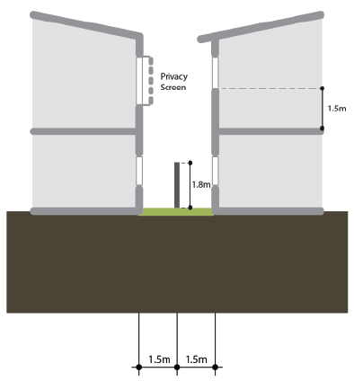  |
|
PO19 Landscaping is provided to enhance the appearance of the development, screen unsightly components, create an attractive on–site environment and provide shading. Note—Applicants are also referred to the Landscaping code. |
No acceptable outcome is nominated. |
|
PO20 Outdoor activity, plant equipment, waste, storage and servicing areas are screened from adjoining properties and from the street. |
AO20 Outdoor activity, plant equipment, waste, storage and servicing areas are:
|
| Effects of development | |
|
PO21 Development responds sensitively to on–site and surrounding topography, drainage patterns, utility services, access, vegetation and adjoining land use, such that:
|
No acceptable outcome is nominated. |
|
PO22 Development maintains a high level of amenity within the site and minimises impacts on surrounding areas, having regard to:
Note—Applicants may be required to engage specialists to provide detailed investigations into the above matters in order to demonstrate compliance with this performance outcome. |
No acceptable outcome is nominated. |
|
PO23 Development is located to:
|
No acceptable outcome is nominated. |
|
PO24 Residential development where located near port facilities, major industries and major infrastructure must mitigate the operational effects including:
|
No acceptable outcome is nominated. |
| Uses – Child care centre, Community care centre or Community use | |
|
PO25 Development is low impact, limited in scale and:
|
No acceptable outcome is nominated. |
|
PO26 Development is highly accessible and is co–located with, or located close to, centres or other community or recreation uses. |
No acceptable outcome is nominated. |
|
PO27 Development does not adversely impact on the amenity of the area. |
AO27 Hours of operation for non–residential development are limited to between 6am and 7pm daily. |
|
PO28 Buildings are located on the site to maximise the residential amenity of residents and neighbours. |
AO28 Buildings are setback a minimum of:
|
|
PO29 Development ensures residential amenity is maintained on adjoining properties. |
AO29 Development provides a 1.8m acoustic screen fence where adjoining a residential use. |
|
PO30 Where a child care centre, development minimises:
|
AO30.1 Where a child care centre, the site is not located on:
|
|
AO30.2 Parking spaces are located so that children are not required to cross the driveway or vehicular access way to reach the building. |
|
| Use – Shop or Food and Drink Outlet (where using an existing non-residential building) | |
|
PO31 Development is low impact and:
|
No acceptable outcome is nominated. |
|
PO32 Development does not adversely impact on residential amenity. |
AO32 The use operates between:
|
Figure 1—Dwelling house: Narrow lot
This form of detached housing enables compact dwelling forms with setbacks that provide natural light and ventilation to habitable rooms and open space for deep planting.
| Element | Acceptable solutions | ||
|---|---|---|---|
| 1.1 | Minimum frontage | 10m | |
| 1.2 | Minimum area | 400m2 | |
| 1.3 | Maximum site cover | 50% | |
| 1.4 | Minimum private open space | 50m2 with a minimum dimension of 6.0m in any direction. | |
| 1.5 | Minimum setbacks | Front | 3m (OMP and including all street frontages where a corner lot). |
| 5m to garage. | |||
| Rear | 6m (where not on a corner lot). | ||
| Side | 1.5m not including eaves. | ||
| 1.6 | Built to boundary walls |
Limited to 1 side boundary and must contain no windows, openings or glazing. Maximum length 10m and maximum height 3.5m. |
|
|
|
|||
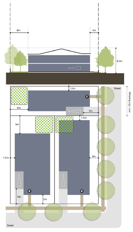
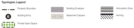
Figure 2—Dual occupancy
These are paired dwellings that share a single internal wall and are visually similar to a dwelling house when viewed from the street.
| Element | Acceptable solutions | ||
|---|---|---|---|
| 2.1 | Minimum frontage | 20m | |
| 2.2 | Minimum area | 600m2 | |
| 2.3 | Maximum site cover | 60% | |
| 2.4 | Minimum private open space | 50m2 with a minimum dimension of 5.0m in any direction. | |
| 2.5 | Minimum setbacks | Front | 3m (OMP and including all street frontages where a corner lot). |
| 5m to garage. | |||
| Rear | 6m (where not on a corner lot). | ||
| Side | 1.5m not including eaves. | ||
| 2.6 | Built to boundary walls |
Limited to 1 side boundary and must contain no windows, openings or glazing. Maximum length 10m and maximum height 3.5m. |
|
|
|
|||
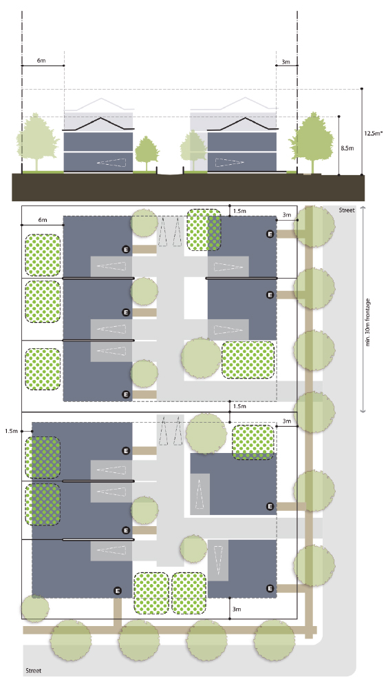
Figure 3—Multiple dwelling: Townhouses
This building type provides for attached dwellings at a low medium density on larger lots where street frontage is limited. Their compatibility with other lower density housing in terms of height and scale makes them ideal for integration into new neighbourhoods or existing residential areas. Vehicle access is from a single driveway with an internal road to car accommodation which is concealed with a building.
| Element | Acceptable solutions | ||
|---|---|---|---|
| 3.1 | Minimum frontage | 30m | |
| 3.2 | Minimum area | 1,200m2 | |
| 3.3 | Maximum site cover | 50% | |
| 3.4 | Minimum open space | 30m2 private open space per dwelling with a minimum dimension of 5m in any direction. | |
| Development greater than 18 dwelling provides a minimum communal open space area of 50m2 with a minimum dimension of 10m. | |||
| 3.5 | Minimum setbacks | Front | 3m (OMP and including all street frontages where a corner lot). |
| 5m to any garage on a street frontage. | |||
| Rear | 6m (where not on a corner lot). | ||
| Side | 1.5m not including eaves. | ||
| 3.6 | Built to boundary walls | Limited to 1 side boundary and must contain no windows, openings or glazing. Maximum length 10m and maximum height 3.5m. | |
| 3.7 | Built form and streetscape |
Maximum of 4 dwellings in a row without separation. |
|
|
|
|||