• Skip to content
  • Skip to navigation
Print header
X

  • (07) 4970 0700
  • Online Services

«Back to
Gladstone Regional Council

Version 1 - Superseded Planning Scheme

  • Citation and commencement
  • Part 1 About the planning scheme
      BackPart 1 About the planning scheme
    • 1.1 Introduction
    • 1.2 Planning scheme components
    • 1.3 Interpretation
    • 1.4 Categories of development
    • 1.5 Hierarchy of assessment criteria
    • 1.6 Building work regulated under the planning scheme
    • 1.7 Local government administrative matters
  • Part 2 State planning provisions
      BackPart 2 State planning provisions
    • 2.1 State planning policy
    • 2.2 Regional plan
    • 2.3 Referral agency delegations
    • 2.4 Standard planning scheme provisions
  • Part 3 Strategic framework
      BackPart 3 Strategic framework
    • 3.1 Preliminary
    • 3.2 Strategic intent Open
        Back3.2 Strategic intent
      • The Gladstone Region Places Model
    • 3.3 Gateway to the world
    • 3.4 Community living
    • 3.5 Connecting our places
    • 3.6 Building it better: our urban areas
    • 3.7 Our environment and heritage
    • 3.8 Our rural and coastal townships and places
  • Part 4 Local Government Infrastructure Plan (LGIP)
      BackPart 4 Local Government Infrastructure Plan (LGIP)
    • 4.1 Preliminary Open
        Back4.1 Preliminary
      • 4.1.1 Introduction
      • 4.1.2 Purpose
      • 4.1.3 Structure of Local Government Infrastructure Plan
    • 4.2 Planning assumptions Open
        Back4.2 Planning assumptions
      • 4.2.1 Purpose
      • 4.2.2 Population and employment growth
      • 4.2.3 Infrastructure areas
      • 4.2.4 Desired standards of service
      • 4.2.5 Plans for trunk infrastructure
      • 4.2.7 Schedules of works
      • 4.2.8 Extrinsic material
  • Part 5 Tables of assessment
      BackPart 5 Tables of assessment
    • 5.1 Preliminary
    • 5.2 Reading the tables
    • 5.3 Levels of assessment
    • 5.4 Prescribed levels of assessment
    • 5.5 Levels of assessment—Material change of use Open
        Back5.5 Levels of assessment—Material change of use
      • 5.5.1 Low density residential zone
      • 5.5.2 Low-medium density residential zone
      • 5.5.3 Medium density residential zone
      • 5.5.4 Character residential zone
      • 5.5.5 Emerging community zone
      • 5.5.6 Mixed use zone
      • 5.5.7 Centre zone
      • 5.5.8 Principal centre zone
      • 5.5.9 Neighbourhood centre zone
      • 5.5.10 Specialised centre zone
      • 5.5.11 Low impact industry zone
      • 5.5.12 Medium impact industry zone
      • 5.5.13 Special industry zone
      • 5.5.14 Industry investigation zone
      • 5.5.15 Special purpose zone
      • 5.5.16 Rural zone
      • 5.5.17 Rural residential zone
      • 5.5.18 Township zone
      • 5.5.19 Major tourism zone
      • 5.5.20 Minor tourism zone
      • 5.5.21 Community facilities zone
      • 5.5.22 Sport and recreation zone
      • 5.5.23 Open space zone
      • 5.5.24 Environmental management zone
      • 5.5.25 Conservation zone
      • 5.5.26 Limited development zone (constrained land)
    • 5.6 Levels of assessment: Reconfiguring a lot
    • 5.7 Levels of assessment: Building work
    • 5.8 Levels of assessment: Operational work
    • 5.9 Levels of assessment: Local plans
    • 5.10 Levels of assessment: Overlays
  • Part 6 Zones
      BackPart 6 Zones
    • 6.2 Zone codes Open
        Back6.2 Zone codes
      • 6.2.1 Low density residential
      • 6.2.2 Low-medium density residential
      • 6.2.3 Medium density residential
      • 6.2.4 Character residential
      • 6.2.5 Centre
      • 6.2.6 Principal centre
      • 6.2.7 Neighbourhood centre
      • 6.2.8 Sport and recreation
      • 6.2.9 Open space
      • 6.2.10 Environmental management
      • 6.2.11 Conservation
      • 6.2.12 Low impact industry
      • 6.2.13 Medium impact industry
      • 6.2.14 Special industry
      • 6.2.15 Industry investigation
      • 6.2.16 Major tourism
      • 6.2.17 Minor tourism
      • 6.2.18 Community facilities
      • 6.2.19 Emerging community
      • 6.2.20 Limited development
      • 6.2.21 Mixed use
      • 6.2.22 Rural
      • 6.2.23 Rural residential
      • 6.2.24 Special purpose
      • 6.2.25 Specialised centre
      • 6.2.26 Township
  • Part 7 Local plans
  • Part 8 Overlays
      BackPart 8 Overlays
    • 8.2 Overlay codes
        Back8.2 Overlay codes
      • 8.2.1 Acid sulfate soils
      • 8.2.2 Airport environs
      • 8.2.3 Biodiversity
      • 8.2.4 Bushfire hazard
      • 8.2.5 Coastal hazard
      • 8.2.6 Extractive resources and minerals
      • 8.2.7 Flood hazard
      • 8.2.8 Hazardous activities
      • 8.2.9 Heritage
      • 8.2.10 Regional infrastructure
      • 8.2.11 Scenic amenity
      • 8.2.12 Steep land
      • 8.2.13 Water resource catchment
  • Part 9 Development codes
      BackPart 9 Development codes
    • 9.2 Statewide codes
    • 9.3 Use codes Open
        Back9.3 Use codes
      • 9.3.1 Development design
      • 9.3.2 Extractive industry
      • 9.3.3 Home based business
      • 9.3.4 Landscaping
      • 9.3.5 Operational works
      • 9.3.6 Reconfiguring a lot
      • 9.3.7 Telecommunications facility use
  • Part 10 Other plans
  • Schedule 1 Definitions
      BackSchedule 1 Definitions
    • SC1.1 Use definitions Open
        BackSC1.1 Use definitions
      • SC1.1.1 Defined activity groups
      • SC1.1.2 Industry thresholds
      • Table Sc1.1.1—Index of use definitions
    • SC1.2 Administrative definitions
  • Schedule 2 Mapping
  • Schedule 3 Local Government Infrastructure Plan (LGIP) mapping and tables
      BackSchedule 3 Local Government Infrastructure Plan (LGIP) mapping and tables
    • SC3.1 Planning assumptions tables
    • SC3.2 Schedules of works
    • SC3.3 Local government infrastructure plan maps
    • SC3.4 Glossary and abbreviations
  • Schedule 4 Notations required under the Sustainable Planning Act 2009
  • Schedule 5 Land designated for community infrastructure
  • Schedule 6 Planning scheme policies
      BackSchedule 6 Planning scheme policies
    • SC6.1 Planning scheme policy index
    • SC6.2 Engineering design
    • SC6.3 Flood hazard
    • SC6.4 Heritage
    • SC6.5 Non–resident workers accommodation
    • SC6.6 Vehicle parking rates
    • SC6.7 Waste management
  • Appendices​
      BackAppendices​
    • Appendix 1 - Index and glossary of abbreviations and acronyms
    • Appendix 2 - Table of amendments
Version 1 - Superseded Planning Scheme
  1. Home
  2. Version 1 - Superseded Planning Scheme
  3. Part 8 Overlays
  4. 8.2 Overlay codes
  5. 8.2.10 Regional infrastructure
Back
Online Mapping

8.2.10 Regional infrastructure

8.2.10.1 Application

This code applies to development where the code is identified as applicable in the table of assessment for the Regional infrastructure overlay code. When using this code, reference should be made to section 5.3.2 and where applicable, section 5.3.3 located in Part 5.

8.2.10.2 Purpose

  1. The purpose of the Regional infrastructure overlay code is to protect regionally significant infrastructure from nearby development that is sensitive to, or creates a risk for the infrastructure, and to protect nearby development from the potential impacts of the infrastructure.
  2. The purpose of the code will be achieved through the following overall outcomes:
    1. Infrastructure requirements are integrated in master planning and subdivision of newly developing areas, including new neighbourhoods.
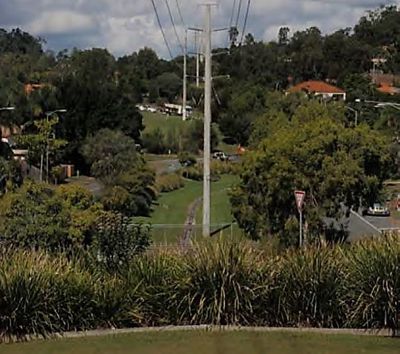
    2. Effective separation and interface treatment is provided to major infrastructure sites and corridors to avoid risk to people and property and to minimise noise, odour and visual impacts.
    3. Easy access is provided to and along major infrastructure sites and corridors.
    4. Development does not compromise the safe and efficient operation, maintenance or expansion of major infrastructure.
    5. Existing and planned regional infrastructure facilities and corridors are protected from encroachment by sensitive land uses or incompatible development.
    6. Development does not create any threat to the provision of a safe and reliable supply of services to all users, and avoids any potential interference with the ongoing operation, maintenance and augmentation of the infrastructure.
    7. Development does not increase the potential for safety concerns, nuisance and complaints and minimises the need for measures to be introduced in the operation of the infrastructure to reduce potential impacts on surrounding areas.
    8. Development minimises overlooking of and visual exposure to the infrastructure sites and corridors.
    9. Development over or near major electricity and bulk water supply infrastructure does not compromise or interfere with the integrity of the infrastructure.

8.2.10.3 Assessment criteria

Table 8.2.10.3.1—Assessable development

Performance outcomes Acceptable outcomes
Reconfiguring a lot ​

PO1

Reconfiguration of lots does not compromise or adversely impact upon the efficiency and integrity of major electricity and bulk water supply infrastructure networks.

No acceptable outcome is nominated.

PO2

Lot reconfiguration integrates major infrastructure sites and corridors within the overall layout. In particular, the neighbourhood design:

  1. ensures land of sufficient size and suitability is allocated to accommodate the existing and future major infrastructure network
  2. as far as possible, minimises the likely visual prominence of major infrastructure, and
  3. provides for an interface or relationship with surrounding uses that minimises the potential for nuisance (including noise and odour), health and safety concerns.

No acceptable outcome is nominated.

Note—Applicants should consult with the electricity providers early in the master planning process to determine electricity infrastructure requirements.

PO3

Landscaping is provided which substantively assists in screening and softening poles, towers or other structures and equipment associated with major infrastructure.

AO3

A minimum 5m wide densely planted landscaped buffer is provided, including provision for advanced trees and shrubs that will grow to a minimum height of 10m.

Note—Applicants may find further guidance in Powerlink's "Screening your home from powerlines – A guide for planting trees and shrubs outside of easements to screen powerlines".

PO4

Development within a water supply pipeline and buffer identified on the Regional infrastructure overlay map:

  1. is located, designed and constructed to protect the integrity of the water supply pipeline, and
  2. maintains adequate access for any required maintenance or upgrading work to the water supply pipeline.

AO4

Buildings and structures (other than those associated with electricity infrastructure) are setback a minimum of 10m from a water supply pipeline as identified on the Regional infrastructure overlay map.

PO5

Where the reconfiguration involves a major electricity infrastructure corridor, the corridor is incorporated within a useable public open space network wherever possible.

No acceptable outcome is nominated.

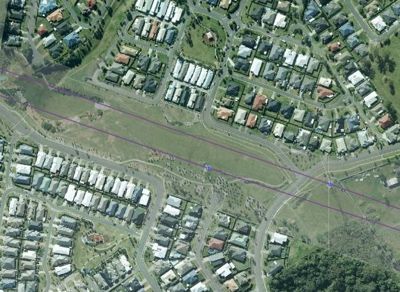
PO6

Where major electricity infrastructure is located within public open space, the dimensions and characteristics of the open space area are sufficient to accommodate the electricity easement or site, in combination with compatible recreational facilities and landscaping, so that:

  1. it has an open and expansive character, with landscape design which assists in breaking up the linear and vertical dominance of the infrastructure
  2. landscaping is located outside the easement area and substantively screens and softens the appearance of poles, towers or other structures, and
  3. recreational facilities and landscaping are compatible with the electricity infrastructure, having regard to safety, height, the conductivity of materials and access to the electricity infrastructure by the electricity provider.

No acceptable outcome is nominated.

Note—The figures below provide an example of a well–integrated transmission corridor.

8 2 10 Po6 - rz 

8 2 10 Po6 - 2 rz 

PO7

Where major electricity infrastructure is located in a road:

  1. an attractive, functional and safe streetscape is achieved
  2. street furniture, planting and lighting are compatible with the electricity infrastructure, having regard to safety, height, the conductivity of materials
  3. the reserve has sufficient width to accommodate significant landscaping which assists in screening and softening poles, towers or other structures and equipment from nearby sensitive land uses
  4. the clearances required under schedules 4 and 5 of the Electrical Safety Regulations 2002 can be achieved, and
  5. convenient access to the infrastructure by the electricity provider is maintained.
No acceptable outcome is nominated.
Material change of use ​

PO8

Development does not increase risk to community health or safety, or the operation and reliability of major electricity or bulk water supply infrastructure.

No acceptable outcome is nominated.

PO9

Development involving a sensitive land use is sufficiently separated from major electricity or bulk water supply and wastewater infrastructure to minimise the likelihood of nuisance or complaint.

​

For electricity infrastructure.

AO9.1

Buildings (other than class 10 buildings) maintain a setback of at least:

  1. 50m from a transmission (Powerlink operated) substation
  2. 20m from any other substation, and
  3. 20m from a transmission line easement.

For water or wastewater treatment plants

AO9.2

Sensitive land uses are not established or intensified within the buffer of a water or wastewater treatment plants identified on the Regional Infrastructure Overlay Map.

PO10

Development avoids potential noise nuisance from substations.

AO10

Noise emissions do not exceed 5db(A) above background noise level at the facia of a building measured in accordance with AS 1055.

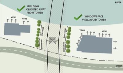
PO11

Other than where they are separated from the infrastructure by a road, buildings are oriented to avoid direct overlooking of major electricity infrastructure or substations.

No acceptable outcome is nominated.

Note—The figure below provides an illustration of buildings oriented away from infrastructure.

8 2 10 Po11 - rz 

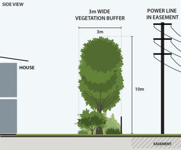
PO12

Development includes sufficient space within the site to establish landscaping which substantively assists in screening and softening poles, towers or other structures and equipment associated with major electricity infrastructure and substations.

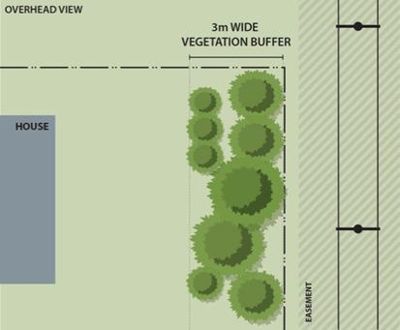
AO12

A minimum 3m wide densely planted landscaped buffer is provided along the boundary adjoining the major electricity infrastructure, including provision for advanced trees and shrubs that will grow to a minimum height of 10m.

Note—The figures below provide an example but are not drawn to scale. Applicants may find guidance in Powerlink's "Screening your home from powerlines – A guide for planting trees and shrubs outside of easements to screen powerlines". Applicants should also note that vegetation will need to maintain statutory clearances (refer Ergon's Standard for Vegetation Management and Standard for Vegetation Clearance Profile.) Applicants should also note that vegetation will need to maintain statutory clearances (refer Ergon's Standard for Vegetation Management and Standard for Vegetation Clearance Profile)

8 2 10 Po12 1 - rz 

8 2 10 Po12 2 - rz 

PO13

Major electricity or bulk water supply infrastructure within private land is protected by easement in favour of the service provider.

AO13

Existing easements are maintained and where none currently exist, new easements are created which are sufficient for the provider's requirements.

PO14

Development does not compromise or adversely impact upon the efficiency and integrity of major electricity and bulk water supply infrastructure networks.

AO14

For bulk water infrastructure, buildings and structures (other than those associated with electricity infrastructure) are setback a minimum of 20m from a water supply pipeline.

No acceptable outcome for major electricity infrastructure.

Operational works and infrastructure ​

PO15

Development within a water supply infrastructure buffer is located, designed and constructed to:

  1. protect the integrity of the water supply infrastructure
  2. maintains adequate access for any required maintenance or upgrading work to the water supply infrastructure.

AO15

Development does not involve works within a water supply infrastructure buffer.

PO16

Earthworks do not restrict access to substations or to and along major electricity infrastructure by the electricity providers, using their normal vehicles and equipment.

No acceptable outcome is nominated.

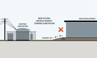
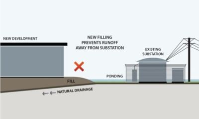
PO17

There is no worsening of flooding, drainage or erosion conditions affecting the infrastructure.

No acceptable outcome is nominated.

Note—The figures below illustrate the concept.

8 2 10 Po17 1 - rz 

8 2 10 Po17 2 - rz 

PO18

Development maintains the clearances required under schedules 4 and 5 of the Electrical Safety Regulations 2002.

No acceptable outcome is nominated.

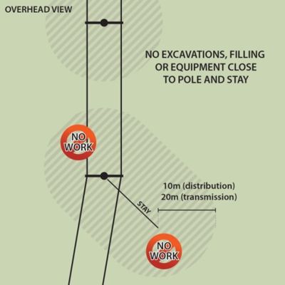
PO19

Any earthworks are undertaken in a way which:

  1. ensures stability of the land on or adjoining substations and major electricity infrastructure
  2. does not otherwise impact on the safety and reliability of the electricity infrastructure, and
  3. does not restrict the placement or use of the electricity provider's equipment.
​

AO19.1

No earthworks are undertaken:

  1. for overhead transmission infrastructure, within 20m of a transmission tower or pole
  2. for overhead distribution infrastructure, within 10m of a tower, pole or stay, or
  3. for substations, within 10m of a property boundary shared with the substation.

Note—The figures below illustrate the concept.

8 2 10 Po19 1 - rz 

8 2 10 Po19 2 - rz 

AO19.2

No earthworks are undertaken, or other loading or displacement of earth caused, within the easement of an underground power line.

PO20

Other services and infrastructure works (such as stormwater, sewerage, water and the like) do not impact on the safety and reliability of substations or major electricity infrastructure.

​ ​ ​ ​ ​

AO20.1

Underground services are not located within 20m of a tower, pole, stay or substation boundary.

AO20.2

No valve pits occur within:

  1. for transmission infrastructure, 60m of a tower, pole or stay, or
  2. for distribution infrastructure, 20m of a tower, pole or stay.

AO20.3

Pipelines with cathodic protection systems, comply with part 11 of Electrical Safety Regulation 2013.

AO20.4

Underground services traversing an easement, cross at right angles to the overhead or underground lines.

AO20.5

Trenches for services are backfilled to be compacted in 150mm layers to at least 95% modified dry density compaction ratio.

AO20.6

Trenches under construction are not left open overnight.

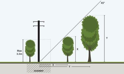
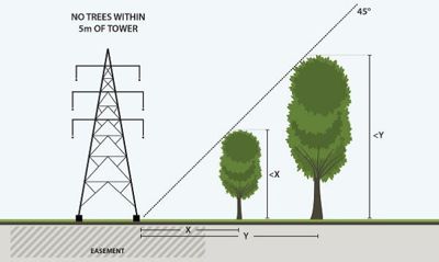
PO21

Vegetation does not pose a risk to the safety or reliability of electricity infrastructure.

​ ​ ​

AO21.1

Vegetation planted within an easement of an overhead power line or, where there is no easement, the area of influence of a power line, has a mature height of no more than 3.5m.

AO21.2

Vegetation planted within an underground power line easement does not have a mature root system in >150mm depth and is not located directly over the power line.

AO21.3

Vegetation adjoining easements complies with the clearance dimensions illustrated in the figure below.

8 2 10 Po21 1 - rz 

8 2 10 Po21 2 - rz 

AO21.4

Planting complies with (as relevant to the infrastructure concerned):

  1. Energex's Safe tree guidelines, or
  2. Ergon's Plant Smart informatin at www.ergon.com.au, or
  3. Powerlink's Screening your home from powerlines information sheet at www.powerlink.com.au.
Online Mapping

Version 1 - Superseded Planning Scheme

SELECT
  • Citation and commencement
  • Part 1 About the planning scheme
      BackPart 1 About the planning scheme
    • 1.1 Introduction
    • 1.2 Planning scheme components
    • 1.3 Interpretation
    • 1.4 Categories of development
    • 1.5 Hierarchy of assessment criteria
    • 1.6 Building work regulated under the planning scheme
    • 1.7 Local government administrative matters
  • Part 2 State planning provisions
      BackPart 2 State planning provisions
    • 2.1 State planning policy
    • 2.2 Regional plan
    • 2.3 Referral agency delegations
    • 2.4 Standard planning scheme provisions
  • Part 3 Strategic framework
      BackPart 3 Strategic framework
    • 3.1 Preliminary
    • 3.2 Strategic intent Open
        Back3.2 Strategic intent
      • The Gladstone Region Places Model
    • 3.3 Gateway to the world
    • 3.4 Community living
    • 3.5 Connecting our places
    • 3.6 Building it better: our urban areas
    • 3.7 Our environment and heritage
    • 3.8 Our rural and coastal townships and places
  • Part 4 Local Government Infrastructure Plan (LGIP)
      BackPart 4 Local Government Infrastructure Plan (LGIP)
    • 4.1 Preliminary Open
        Back4.1 Preliminary
      • 4.1.1 Introduction
      • 4.1.2 Purpose
      • 4.1.3 Structure of Local Government Infrastructure Plan
    • 4.2 Planning assumptions Open
        Back4.2 Planning assumptions
      • 4.2.1 Purpose
      • 4.2.2 Population and employment growth
      • 4.2.3 Infrastructure areas
      • 4.2.4 Desired standards of service
      • 4.2.5 Plans for trunk infrastructure
      • 4.2.7 Schedules of works
      • 4.2.8 Extrinsic material
  • Part 5 Tables of assessment
      BackPart 5 Tables of assessment
    • 5.1 Preliminary
    • 5.2 Reading the tables
    • 5.3 Levels of assessment
    • 5.4 Prescribed levels of assessment
    • 5.5 Levels of assessment—Material change of use Open
        Back5.5 Levels of assessment—Material change of use
      • 5.5.1 Low density residential zone
      • 5.5.2 Low-medium density residential zone
      • 5.5.3 Medium density residential zone
      • 5.5.4 Character residential zone
      • 5.5.5 Emerging community zone
      • 5.5.6 Mixed use zone
      • 5.5.7 Centre zone
      • 5.5.8 Principal centre zone
      • 5.5.9 Neighbourhood centre zone
      • 5.5.10 Specialised centre zone
      • 5.5.11 Low impact industry zone
      • 5.5.12 Medium impact industry zone
      • 5.5.13 Special industry zone
      • 5.5.14 Industry investigation zone
      • 5.5.15 Special purpose zone
      • 5.5.16 Rural zone
      • 5.5.17 Rural residential zone
      • 5.5.18 Township zone
      • 5.5.19 Major tourism zone
      • 5.5.20 Minor tourism zone
      • 5.5.21 Community facilities zone
      • 5.5.22 Sport and recreation zone
      • 5.5.23 Open space zone
      • 5.5.24 Environmental management zone
      • 5.5.25 Conservation zone
      • 5.5.26 Limited development zone (constrained land)
    • 5.6 Levels of assessment: Reconfiguring a lot
    • 5.7 Levels of assessment: Building work
    • 5.8 Levels of assessment: Operational work
    • 5.9 Levels of assessment: Local plans
    • 5.10 Levels of assessment: Overlays
  • Part 6 Zones
      BackPart 6 Zones
    • 6.2 Zone codes Open
        Back6.2 Zone codes
      • 6.2.1 Low density residential
      • 6.2.2 Low-medium density residential
      • 6.2.3 Medium density residential
      • 6.2.4 Character residential
      • 6.2.5 Centre
      • 6.2.6 Principal centre
      • 6.2.7 Neighbourhood centre
      • 6.2.8 Sport and recreation
      • 6.2.9 Open space
      • 6.2.10 Environmental management
      • 6.2.11 Conservation
      • 6.2.12 Low impact industry
      • 6.2.13 Medium impact industry
      • 6.2.14 Special industry
      • 6.2.15 Industry investigation
      • 6.2.16 Major tourism
      • 6.2.17 Minor tourism
      • 6.2.18 Community facilities
      • 6.2.19 Emerging community
      • 6.2.20 Limited development
      • 6.2.21 Mixed use
      • 6.2.22 Rural
      • 6.2.23 Rural residential
      • 6.2.24 Special purpose
      • 6.2.25 Specialised centre
      • 6.2.26 Township
  • Part 7 Local plans
  • Part 8 Overlays
      BackPart 8 Overlays
    • 8.2 Overlay codes
        Back8.2 Overlay codes
      • 8.2.1 Acid sulfate soils
      • 8.2.2 Airport environs
      • 8.2.3 Biodiversity
      • 8.2.4 Bushfire hazard
      • 8.2.5 Coastal hazard
      • 8.2.6 Extractive resources and minerals
      • 8.2.7 Flood hazard
      • 8.2.8 Hazardous activities
      • 8.2.9 Heritage
      • 8.2.10 Regional infrastructure
      • 8.2.11 Scenic amenity
      • 8.2.12 Steep land
      • 8.2.13 Water resource catchment
  • Part 9 Development codes
      BackPart 9 Development codes
    • 9.2 Statewide codes
    • 9.3 Use codes Open
        Back9.3 Use codes
      • 9.3.1 Development design
      • 9.3.2 Extractive industry
      • 9.3.3 Home based business
      • 9.3.4 Landscaping
      • 9.3.5 Operational works
      • 9.3.6 Reconfiguring a lot
      • 9.3.7 Telecommunications facility use
  • Part 10 Other plans
  • Schedule 1 Definitions
      BackSchedule 1 Definitions
    • SC1.1 Use definitions Open
        BackSC1.1 Use definitions
      • SC1.1.1 Defined activity groups
      • SC1.1.2 Industry thresholds
      • Table Sc1.1.1—Index of use definitions
    • SC1.2 Administrative definitions
  • Schedule 2 Mapping
  • Schedule 3 Local Government Infrastructure Plan (LGIP) mapping and tables
      BackSchedule 3 Local Government Infrastructure Plan (LGIP) mapping and tables
    • SC3.1 Planning assumptions tables
    • SC3.2 Schedules of works
    • SC3.3 Local government infrastructure plan maps
    • SC3.4 Glossary and abbreviations
  • Schedule 4 Notations required under the Sustainable Planning Act 2009
  • Schedule 5 Land designated for community infrastructure
  • Schedule 6 Planning scheme policies
      BackSchedule 6 Planning scheme policies
    • SC6.1 Planning scheme policy index
    • SC6.2 Engineering design
    • SC6.3 Flood hazard
    • SC6.4 Heritage
    • SC6.5 Non–resident workers accommodation
    • SC6.6 Vehicle parking rates
    • SC6.7 Waste management
  • Appendices​
      BackAppendices​
    • Appendix 1 - Index and glossary of abbreviations and acronyms
    • Appendix 2 - Table of amendments

Gladstone Regional Council

Connect. Innovate. Diversify.

Return to top

Get in Touch

Phone

(07) 4970 0700

Opening Hours

8.30am - 5pm Monday to Friday

Social media

Contact Us  Email Us

Postal Address

PO Box 29, Gladstone Qld 4680

Council Offices

101 Goondoon Street, Gladstone Qld 4680
3 Don Cameron Drive, Calliope Qld 4680
41 Blomfield Street, Miriam Vale Qld 4677
Cnr Wyndham & Hayes Avenues, Boyne Island Qld 4680

Rural Transaction Centres

71 Springs Road, Agnes Water Qld 4677
47 Raglan Street, Mount Larcom Qld 4695

Footer Image Links

Gladstone Regional Council Logor Gladstone Entertainment Convention Centre Logo Gladstone Regional Art Gallery and Museum Logo Gladstone Regional Libraries Logo Gladstone Tondoon Botanic Gardens Logo Philip Street Communities and Families Precinct

Footer Acknowledgement

Gladstone Regional Council would like to acknowledge the Bailai, the Gurang, the Gooreng Gooreng and the Taribelang Bunda people who are the traditional custodians of this land. Gladstone Regional Council would also like to pay respect to Elders both past, present and emerging, and extend that respect to other Aboriginal and Torres Strait Islander people. Learn more about Council's Reconciliation Action Plan (RAP).

Chat Popup

Launch Chat

© 2025 Gladstone Regional Council

All content © Gladstone Regional Council Planning Scheme. All Rights Reserved.

Powered by Jadu Central.

  • Privacy
  • Right to Information
  • Login
Back to the top
Print footer